With only less than 1 mi² wedged between sea and mountains, the Principality of Monaco is the smallest city-state in the world, except for the Vatican. In order to keep this cramped, coastal and rocky piece of land viable and sovereign, its development has been a major challenge that has been constantly renewed for 150 years.
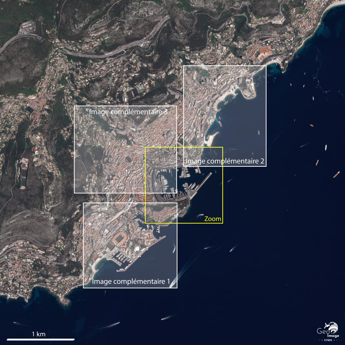
Image information
This image was taken by a Pleiades satellite on 02/06/2019. It is a natural color image, native resolution at 0.70m, re-sampled at 0.5m.
General Presentation of the image
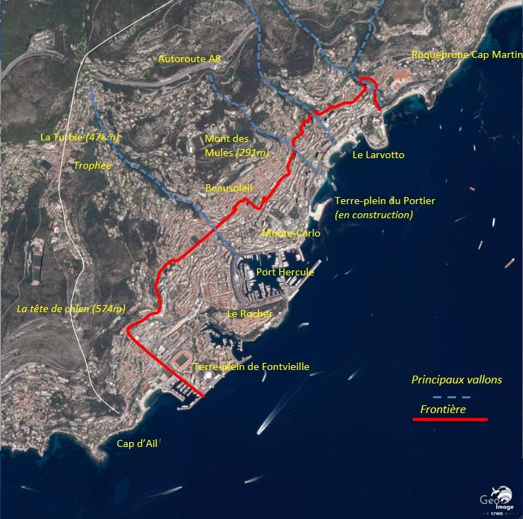
The Principality of Monaco : the overvalorization of a very limited space, between the border limit in the north and the coastal maritime extensions in the south
A limited, steep and constrained site between sea and mountains
The image shows the eastern littoral fringe of the Alpes-Maritimes, 12 mi from Nice and 6 mi from the Italian border, overlooking the Principality of Monaco.
It is a steep site, the first Alpine slopes literally plunging into the Mediterranean Sea. A high ridge line between 1600 and 2300 ft surrounds the Monegasque metropolitan area, from Tête de Chien (1880 ft) in the south, to Mont Gros (2250 ft) in the north. The Tête de Chien anticline, running north-south, has its faulted eastern flank that ends in a steep 490 ft cliff.
This ridge descends to the pass and La Turbie village (1680 ft), a historic passage from the coast. In the north-west corner of the image, we can see the motorway passing today under the Col de Guerre (1820 ft) and then up the mountainside at an altitude of 1390 ft. From La Turbie, the terrain climbs up to Mont Gros in the north, thus delimiting a theater steeply sloping down to the sea, marked by steep regular slopes, notched by four deep valleys.
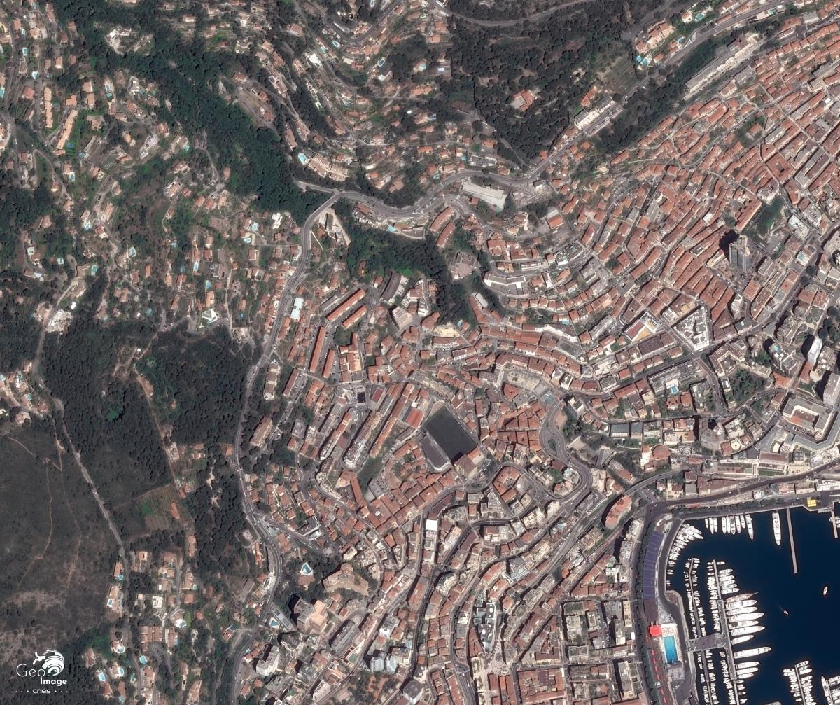
The widest of these valleys is that of the Moneghetti in the west, forming a natural axis from the north-west corner of the port of Monaco to La Turbie. The other three, (from west to east, the Noix valley, the Rousse valley, and the Saint-Roman valley) are oriented north-west - south-east, normally on the shore and organize the space. The slopes of these valleys are often very steep, and they leave on the interfluves very few flats, sometimes occupied by giants scree. All this contributes to favoring the gullying, especially as the Mediterranean rains regime makes long intense showers spread over a few days and determines a strong torrentiality. That said, the rivers in these valleys are temporary, for the most part captured and stopped by the channeling of the main beds in inhabited areas and by very dense coastal urbanization.
The image is centered on the Principality of Monaco which stretches for almost 2,5 mi along the Mediterranean coast. With an area of only 0,78 mi², the population density is one of the highest in the world, with more than 18,000 inhabitants / km². The population of Monaco is estimated at 38,000 inhabitants, of which only 9,300 (25%) have Monegasque nationality. There are 143 other nationalities.
The development of such a craggy and cramped coastal site was therefore very often vital, and the main challenge that the Principality had to meet in order to remain today a sovereign state, economically viable, while assuming its international appeal.
1861: Monaco challenged by its space
A geopolitical issue: Remain sovereign. In 1861, although not forming part of the County of Nice ceded to France, Monaco paid the price for the “tips policy” led by Napoleon III with regard to Savoy. The Sardinian States in fact imposed on Monaco self-determination referendums on the subject of the cities of Roquebrune and Menton - free cities since their secession in 1848. The Roquebrunoise and Mentonnaise populations on this occasion ratified their attachment to France. The Monegasque territory then acquires its current borders, amputated of most of its land and its resources, and now landlocked by a powerful state, effectively abandoning its border position.
An economic stake: Remain viable. Knowing that they can no longer play on his frontier position and deprived of his traditional resources, Charles III deliberately orients the economy of the territory towards that of luxury and gambling with the help of François Blanc. Already with solid experience in this field in Luxembourg and Germany, he began developing the promontory north of the port, entirely dedicated to gambling, which would become Monte-Carlo. As the gambling economy was then banned in both France and Italy, the whole of European high society came during winter-time in Monte-Carlo.
The principality experienced a considerable economic boom from 1863 through the SBM (Société des Bains de Mer), the casino and its Garnier opera house, luxury hotels and properties. There also was a significant flow of employees who came to live on the heights beyond Monaco’s borders. This territory will end up being detached in 1898 from the municipality of La Turbie to create a new town inhabited by the working-class, bordering Monaco and in its hand, since administered by F. Blanc’s son : Beausoleil.
A territorial issue : Opening up. A lifelong concern of this abrupt coastal area, transport and mobility infrastructures is of particular importance. As the environment is mountainous, any access requires cutting rocks, boring tunnels, and stepping over valleys. So much so that we attribute to the first roads serving the Monegasque territory a divine origin since it would be Hercules himself who would have cleared his way in order to bring back to Greece the oxen stolen from Géryon. The fact is that a cult to Hercules developed there, that toponymy has preserved the port of Hercules, furthermore a sanctuary probably established on the heights near the Augustus’s trophy undoubtedly determined the location of the trophy and the construction of a new Roman road: Via Julia Augusta.
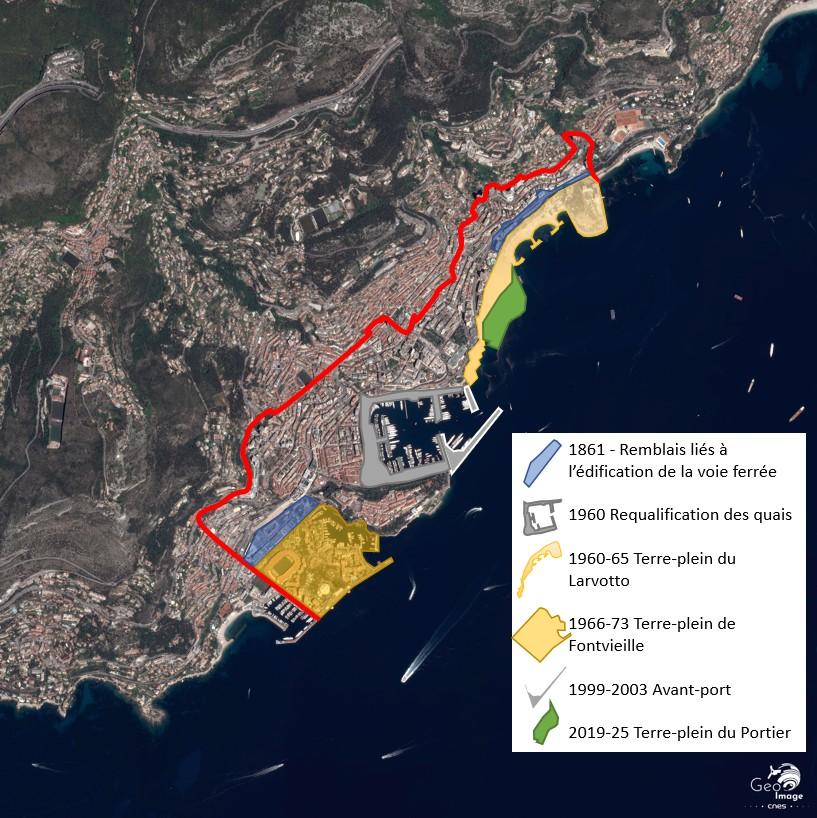
This major issue had not escaped the notice of F. Blanc and Charles III either. With the loss of Menton and Roquebrune, the Prince had succeeded in negotiating with Napoleon III in addition to 4 million gold francs in compensation, the promises of a new road (the current Basse Corniche, coastal road pierced from Nice in 1861), and especially the arrival of the railway the same year, extended to Menton in 1869. The construction of the railway is also at the origin of the first Monegasque territorial extensions (still terrestrial), since it is necessary to develop flat terraces using retaining walls and embankments.
The metamorphosis of the 1960s and 1970s : Current dynamics and legacies
A geopolitical issue : Remain sovereign. When De Gaulle imposed a six month blockade on Monaco in 1963, it reminded Le Rocher how dangerous French confinement could be. The cause was mainly tax policy and the gradual establishment in the interwar period of what has come to be called a tax haven. The French state intended to reaffirm its economic interests - French residents would henceforth remain subject to tax - and to increase the degree of constitutionality of the principality which had shown itself during the war to be very understanding with Vichy and the Germans.
An economic stake : Remain viable. This warning shot in 1963 led Rainier III to adapt his territory to the new world economic situation. The 1960s and 1970s were therefore marked by major developments to develop new economic activities there: an industrial and service activity to supplement banking and financial activities, an expansion of the tourist clientele, and an increase in service to the principality. The smallness then becomes a strong constraint which leads Monaco to optimize the least existing space and to gain some on the sea.
The first territorial gains were made by burying the railway line in two phases: in the north from 1958 until 1964, which allowed the conversion of the track land into a wide road infrastructure making it easier for the Italian workers, and those coming from the eastern part of the department, to commute. This also made it possible to keep the automobile grand prix, born in the 1930s, with ever more powerful mechanics. Then a second territorial gains to the south in the 1990s, burying the station and the rest of the rail line to develop real estate on the land thence freed.
But in addition to the successive rectifications of the port quays, it is indeed the construction of land reclaimed from the sea that has provided the space necessary for Monaco's economic adaptation. Between 1960 and 1965, the platforms in the north of the principality emerged in order to develop a cultural center, housing, two beach coves, a performance hall, a SBM conference center, and a Resort hotel, or nearly 22 acres reclaimed from the sea. We can see the desire to attract cultural events and conference delegates, but also to provide Monaco with seaside areas.
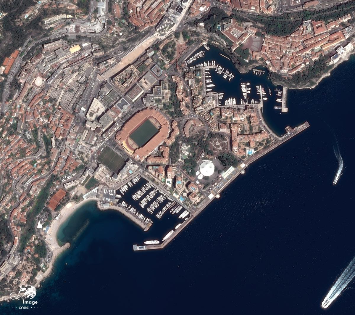
It is above all the Fontvieille platform built between 1966 and 1973 which will offer a vast new flat area of 55 acres with a second marina south of the Rocher. A stadium is located there for sporting events and for the accommodation of its football club A.S Monaco. A shopping center, offices, a few industries and moderately elevated housing - the palace should not be overlooked ... - complete the layout.
A territorial issue : Opening up. Monaco is continuing its necessary opening up. A helipad on the coastal strip of the Fontvieille platform allows the principality to acquire an autonomous air interface. In 1992, a motorway exit ramp was opened from the A8 motorway from Nice, which increased the capacity of commuting from the west. The new underground railway station in 1999 also increased the capacity of its passenger traffic - increased to 6 million passengers per year - with underground accesses serving both Fontvieille and the port.
Today : New contemporary and future challenges
A geopolitical issue : Integrating into the globalized system. In the 2000s, a series of international agreements began, which increasingly integrated Monaco into the world system while providing it with consolidated sovereignty. In 1984, an agreement on its maritime borders gave it a territorial maritime strip of 54 mi directly above its coastal limits. In 1993, the country joined the UN.
In 2002, supported by France in the EU, it entered Schengen and above all adopted the euro. In 2004, Monaco sat on the Council of Europe. In 2005, a series of administrative and technical agreements further strengthened cooperation with French territory, in telecommunications, especially for the deployment of internet fiber. In 2012, 26 tax agreements were signed with various states which brought the principality out of the OECD gray list of tax havens by lifting much of the banking secrecy that had made the reputation of the Rocher.
The Monegasque State is gaining in respectability and integrating itself at its level with international bodies allowing it to play its card in the world of business or international tourism. Monaco is no longer so much the refuge of great fortunes, but, however, tax optimization and its subtle rules, real estate speculation and the acquisition of Monegasque nationality, which still allows its holders to escape income tax, allow it to remain a very attractive place for capital and tax evasion.
An ecological issue : Develop ... up to where ? Develop a saturated space with a weakened ecosystem. The question of economic viability is no longer as acute as it used to be, as the fundamentals remain with a now globalized clientele. The permanence of games and cultural and sporting events, financial activities, continue to attract a wealthy population while Monaco continues to be the main employment area (50,000) to the east of the Alpes-Maritimes department. A semi-floating 383 yd long seawall was nevertheless created between 1999 and 2003 to reinforce the disembarkation of cruise passengers. This made it possible to increase port capacity with the creation of an outer port, to better protect the port from the easterly swell and, inside, a dry port on two floors with parking.
As the whole of the territory is urbanized, tensions in the real estate market are extreme and each urban rehabilitation operation makes it possible to gain even more height. The last tower built in 2015, the Odeon Tower, thus rises to 558 ft, making it the tallest residential tower in Europe.
The issue of sustainability has now shifted more to the environmental aspect. Archetypal of the saturation of the coast, Monaco with its largely degraded ecosystem is now aware of the issues and is posing as a model by hosting, for example, the last meeting of the IPCC. This does not prevent it from having started the construction of a final 6 ha embankment in extension of the pier of Portier's embankment, available in 2025. The installation of crates - up to 115 ft deep - was nevertheless carried out with a concern for the underwater flora and fauna and wants to be an eco-district.
The aim is to limit the impact on the environment, from the choice and preparation of the site, to the construction methods, and the energy supply needs of new buildings. Exclusively pedestrian, on this area, are planned : a small port of 30 rings, a public park of 2,5 acres, in addition to office buildings, commercial spaces, luxury houses, including condominiums and private villas on the waterfront designed by architect Renzo Piano.
The redevelopment of the Fontvieille terraces near the Rocher is the second major urban project planned. Here again, the idea is to integrate and imitate natural elements : the sea and the green slopes of the Mediterranean hills with curved lines evoking the movement of the waves... while gaining an elevation of the buildings. A project which provides for a final transport infrastructure : an urban cable car can be extended to a relief parking lot near the motorway.
Originally provided by a most restrictive territory, Monegasque urban planning has been, at all times, a response to the challenges it had to meet. This development now seems to be reaching its limits with an announced last extension on the sea, a hypothetical urban cable car, all in a context of global warming leading to the idea of increasing the coefficient of vegetation in the Principality.
Detailed images
Port Hercule
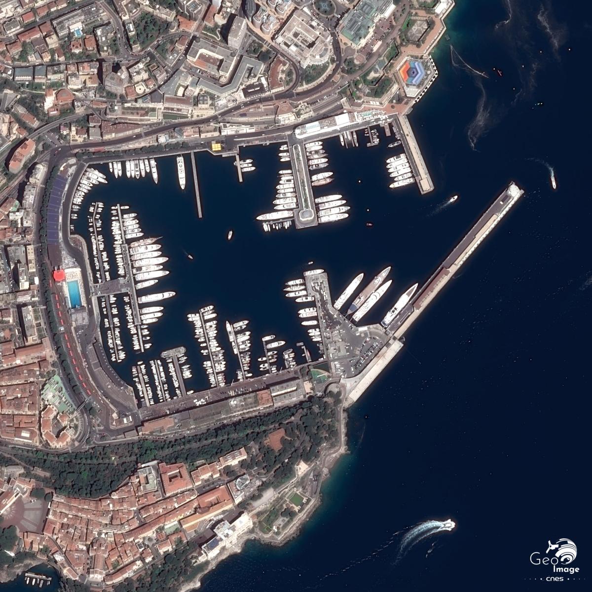
Nestled between the promontories of Monte-Carlo to the north and the Rocher of Monaco to the south, Port Hercules is a welcome maritime shelter on these steep coasts. A simple haven for centuries, the southern position was fortified by the Genoese on the site of the current palace (cut off in the image to the east of the square) and a tower to the west. In between is the first urban core on the Rocher. Its church to the south, erected as a cathedral in 1887, was rebuilt in the neo-byzantine style in 1910. On the south-eastern shore, the oceanographic museum was built in the 19th century directly above the cliff.
To the north, Monte-Carlo, built in the 19th century with its casino and hotels. At the bottom, in the northwest corner of the port, under the old railway bridge which has become a road, deep in the back of the Gaumates cove, is the holy Dévote chapel. It is the first christian establishment at the beginning of the 4th century around the hallows of this young martyr who became patron saint of Monaco. At the south-western corner of the port is a second extramural urban core - the condamine, originally a trading and fishing district.
Gradually, all the docks reach the port. The last central development with the Olympic swimming pool dates from 1961. Finally, the outer harbor created in the early 2000s with the Rainier III’s sea wall and its yacht club on the north shore. This sea wall was built in Algeciras, in Spain, and towed to Monaco for 930 mi in 12 days. It is attached to the embankment crates by a steel ball joint 26 ft in diameter weighing 850 tons. This ball joint is expected to yield to clear the dike in the event of an earthquake.
Complementary images

Further resources
Referencias o complementos bibliográficos
On the CNES Géoimage website:
- Jean-Marc Noaille : Nice : une ville entre mer et montagne, une métropole touristique saturée
/geoimage/nice-une-ville-entre-mer-et-montagne-une-metropole-touristique-saturee - Florian Boizet et Lionnel Clerc : L’Est-Maralpin : un territoire transfrontalier franco-italo-monégaste au cœur de l’arc méditerranéen
Sites:
- Site de l’Institut monégasque de la statistique
- Site du SCOT de la Riviera française
Author
Philippe Briand, Professeur au Lycée PM. Curie de Menton

