With a population of nearly 12 million, London is a world-city (global city) that concentrates high-level metropolitan functions ensuring its international reach and strong integration into globalization. Inner London is its central zone and polarizes power and wealth. In recent years the acceleration of the metropolisation process has resulted in large-scale functional recompositions and urban, real estate and social changes. Major urban regeneration operations supported by international real estate capital are accelerating the rise in land and real estate prices, gentrification of the centre and the phenomena of socio-spatial segregation.
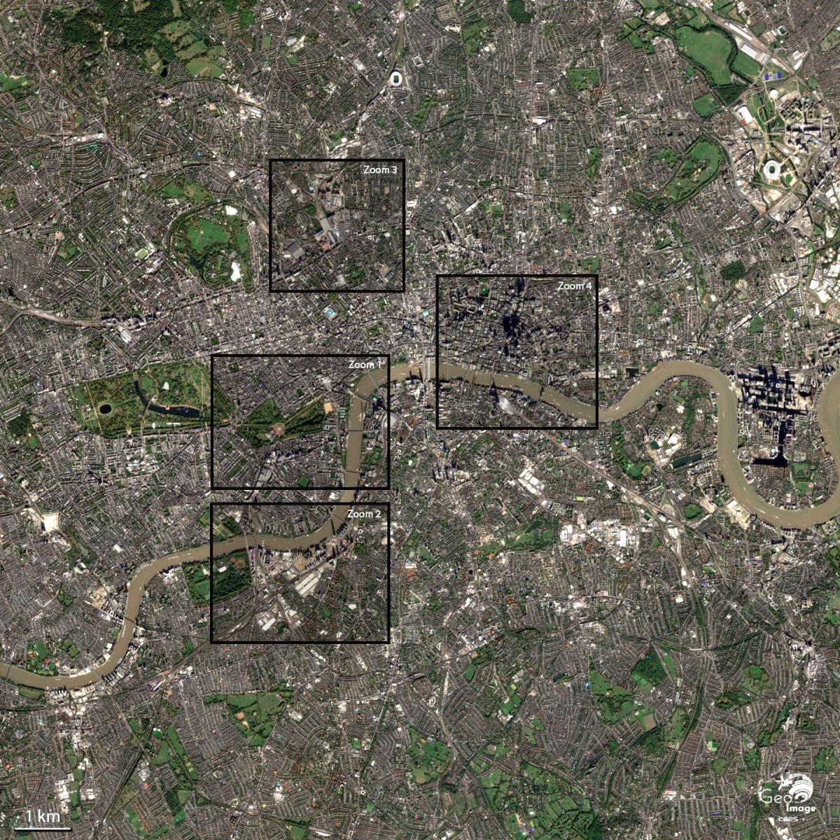
Image captation
This image of London, the capital of England and the United Kingdom, was taken on 26 February 2019 by the Sentinel-2B satellite. It is a 10m resolution natural colour image.
Presentation of the global image
Inner London : Power, Wealth and Urban Change
A capital and a world-city
The image covers a portion of the central districts of London knows as “Inner London”, which are the City, Westminster, Kensington, and Chelsea, Southwark and Lambeth. These neighbourhoods concentrate the bulk of the city’s political, economic, and financial power and wealth.
At the centre of the image, the Thames is a structuring axis in the organization of the city. It reminds us that London is a city of estuary background and that the tide flows back to the east entrance of the historic heart. As such, London belongs to the major metropolises of the Northern Range of Western Atlantic Europe such as Bordeaux, Nantes, Rouen, Antwerp, Rotterdam, Bremen, and Hamburg. But the fluvial and harbour functions (cf. Docklands further east) have long since left this space to slide very widely downstream and towards the estuary.
Organizing a metropolis of nearly 12 million inhabitants, regionally polarizing the entire Greater London Basin and capital of the United Kingdom, London is also a metropolis of world rank, having long had an exceptional imperial status, which concentrates power, wealth, and population.
Metropolisation processes, functional dynamics, and urban changes
In the context of contemporary globalisation, the functional specialisation of the different districts has tended to be reinforced and completely transformed to adapt to the process of metropolisation.
Thus, while political power remains concentrated in the historical district of Westminster, the City, the financial heart of the city is in full mutation. The ever-greater concentration of financial activities has led to a profound transformation of its urban fabric: densification and verticalization of the built, extension towards the east but also duplication for the economic and financial centre of the city more to the East, in the Canary Wharf neighbourhood, the former poor district of the Docklands.
The strong attractiveness of the city and the necessary adaptation of economic activities to the global context led to a major reconstruction of certain central districts: regeneration projects of former industrial districts such as King’s Cross or Nine Elms-Battersea.
The gentrification phenomenon and the rise in land and real estate prices that make it one of the most expensive metropolises in the world, also profoundly transform the sociology of the city-centre and the agglomeration. It is now a major challenge for political authorities and real estate developers: strengthening the competitiveness of the city while allowing its inhabitants to live there.
As we will see through the four-zoom studied next, the urban landscape of the London metropolis is changing, constantly adapting, and renewing itself to maintain and strengthen its positions as a world city, while Brexit is the source of a profound change in London’s anchorage to the European continent.
Zooms
The proposed image shows west-central London, about 3 km southwest of the City on the left bank of the Thames. The Buckingham Palace at the northeast end of Hyde Park and the Thames to the east can be seen in the centre of the image. If the city is the economic heart, Westminster has been concentrating political power since the 11th century when Edward the Confessor decided to leave the City and move to Westminster with is court and administration. Westminster is now a district of London where political power and the city-s richest populations are concentrated.
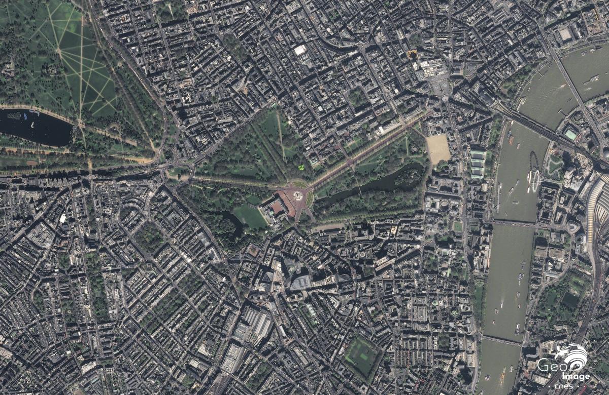
The image shown was taken by a Pléiades satellite on April 8, 2017. It is a natural color image with a native resolution of 0.70 m, resampled to 0.5 m.
A historic political function
As Buckingham Palace shows in the centre of the picture, the main function of the Westminster district is political. Since Queen Victoria was installed in this « new » palace in 1837, Buckingham Palace has become the centre of the monarchical power.
While the power of the British Crown is essentially symbolic today, the Westminster district still concentrates the country’s political decision-making venues. Firs of all, Parliament sits on the banks of the Thames between Westminster Bridge in the north and the Lambeth Bridge in the south, where the House of Commons and the House of the Lords sit. This is the heart of the legislative branch.
The centre of executive power is symbolized by 10 Downing Street, the residence of the Prime Minister, just north of Parliament on the eastern edge of St James’s Park. Several Regalia ministries are deployed along Parliament Street connecting Parliament to Trafalgar Square: The Ministry of Finance with its circular building, the Ministry of Foreign Affairs in front of the Ministry of Defense, it is recognizable by its alignment of four green roofs, or the Ministry of Health. To this can be added the premises of the famous British secret service, the MI5, on the banks of the Thames south of the Parliament.
Along the Mall, which is the great red bitumen artery where official ceremonies are held, there are several prestigious private clubs where the most powerful and influential people of the country gather, such as the Oxford and Cambridge Club and the Royal Automobile Club, frequented by General de Gaulle during the Second World War.
Finally, many embassies have settled close to these places of power in the district of Belgravia recognizable by its beautiful alignment of large mansions surrounded by large gardens common to the west of the image.
To the political function, we can also add the religious function of this district of Westminster with Westminster Abbey, place of coronation and necropolis of the British sovereigns. The presence of this prestigious Abbey in Westminster recalls the close ties between the monarchy and the Anglican Church.
An important heritage and tourism function
While the Changing of the Guard is one of London’s major tourist attractions, the entire Westminster district contributes to the city’s tourist appeal, which is today the leading European tourist destination with Paris with more than 15 million visitors per year.
Buckingham Palace and Big Ben are must-sees, but there are also several parks in this area: St James’s Park and Green Park around Buckingham Palace, Hyde Park in the northwest of the picture. Trafalgar Square is a major gathering place for all major events. North of the square, the National Gallery is one of the world’s largest painting museums.
London of luxury and the rich
This picture of west-central London shows the London of the rich. Indeed, the districts of Belgravia and Knightsbridge to the southwest of the image, and Mayfair to the north, are places of exceptional concentration of the highest heritages.
The district of Belgravia was built from 182O in the style of the fashionable subdivisions in the 18th century. These are 3- to 4-storey neo-classical town residences and townhouses arranged in strips alternating with public or private parks such as Belgrave Square or Eaton Square, this long rectangle facing south-west/north-west that can be found to the south of the picture.
Luxury shops follow one another along avenues such as Brompton Road and Sloane Square. The Harrods department store on Brompton Road can be seen to the west of the image. Along Sloane Street are 5-star hotels and gourmet restaurants.
The proximity of the political and monarchical power explains the strong land pressure of these districts and the extremely high price of real estate. Indeed, from the 19th century, Belgravia attracted English aristocrats who wished to live close to the Parliament and the Palace. It is also about being at the heart of London’s social life. Today, the mansions occupied by English aristocrats have been mostly bought by billionaires. These are coming from Russia, Asia, or the Near East. Their presence contributes to the international status of the metropolis.
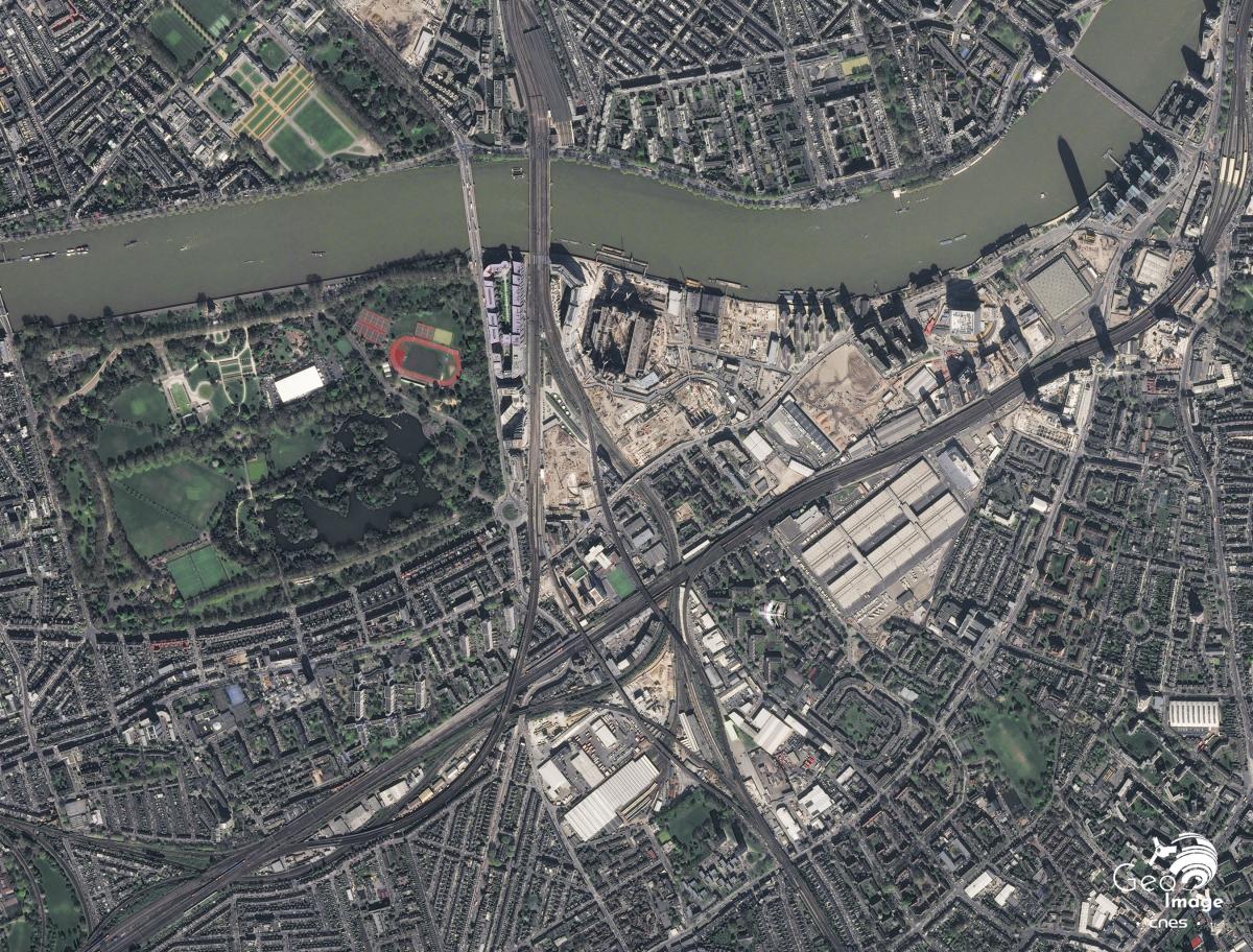
The area studied here extends on the south bank of the River Thames to the west of the city’s historic centre. It belongs to what are called the peri-central districts of Inner London.
The image shows three remarkable elements that characterize this space. First, the Thames is a structuring axis and places this space at the heart of the problems of reclaiming the banks of the river. Second Battersea Park is one of the four largest and most famous parks in London, along with Hyde Park, Regent’s Park and Hampstead Heath. And thirdly, an area that appears to be undergoing a transformation and that corresponds to the perimeter of the urban regeneration program of Vauxhall, Nine Elms, Battersea Opportunity Area.
This space is crossed by numerous railway tracks that break up the urban landscape with a double cut. The first one is constituted by the tracks serving the south of the London agglomeration and of England from the station of Victoria, visible on the zoom to the north of the Thames. There is also an east-west cut of the Vauxhall and Clapham Junction rail hub connecting the west end of the city to Waterloo Station, but also allowing overground traffic.
Battersea: a district at the heart of the projects to reclaim the banks of the Thames
Connected to the north bank of the Thames by the Chelsea Bridge (1858) and the Albert Bridge (1873), Battersea Park was created at the initiative of Queen Victoria and was inaugurated in 1858. It is intended to improve the living conditions of the inhabitants of Chelsea and supports the development of residential housing in the Battersea district while the London metropolis is experiencing a spectacular growth in the Victorian era.
It is still today one of the largest parks in the city of London. Open on the River Thames, it is a very landscaped park with many spaces for children, sports facilities, but also spaces for relaxation visible on the satellite image.
Today, it is a link between the various projects for reclaiming the former industrial banks of the Thames, which must make it possible to regain continuity of circulation along the river through the development of soft mobility as part of a policy to reduce the city’s air pollution. Indeed, to the east of Battersea Park extends a whole perimeter to the landscapes still very marked by the industrial era: the perimeter of regeneration Vauxhall, Nine Elms, Battersea PowerStation.
A working-class industrial district that was impoverished in the 1970s
The area suffered extensive destruction during the Second World War, resulting in the loss of much of the residential habitat of the Victorian era and the release of many spaces. As elsewhere in the city, the British welfare state in the aftermath of the war made the choice to build in these lands freed by the shelling of councils’ estates, or social housing. They are recognizable on the satellite image in the elongated shape of the stick buildings surrounded by green spaces that occupy large plots delimited by streets while only small pedestrian passages provide traffic within them.
Southeast of the image, the large Nine Elms train station and locomotive construction site has been replaced by the New Covent Garden Market, the large fruit, vegetable, and flower markets that supply London with fresh produce.
By the mid-1970s, however, the Nine Elms district was experiencing significant impoverishment due to the decline in industrial activity and the partial closure of the Battersea power station.
A neighbourhood regeneration project to strengthen London’s metropolitan character
Adopted in 2012, the program of regeneration of this perimeter is the last to be adopted to reconquer the industrial wastelands of the banks of the south bank of the Thames. Thought around the renovation of the iconic Battersea Power Station, listed as a historic monument even before its final closure in 1983, the regeneration of this suburban area. The City of London’s metropolitan character is strengthened by promoting the internationalization of its population, of present investors but also tending towards a certain uniformity of urban landscapes marked by a growing verticalization.
It builds on an ambitious project to renovate the Battersea power plant. This is expected to house more than 15,000 new homes, as businesses as Apple to create 20,000 to 25,000 jobs in the neighbourhood. This program is part of a public-private partnership, and it is for example a Malaysian investor who oversees the rehabilitation of Battersea Power Station. In the same way, the 23 hectares occupied by the New Covent Garden Market are integrated into the neighbourhood’s regeneration program. The halls will be preserved but part of the land will be allotted in luxury residences to finance their modernization.
The City of London supports this project through the development of the transport network with the extension of a major metro line - the Northern Line - to the south bank of the River Thames and the opening of two stations within the scope of the regeneration programme (Battersea Power Station and Nine Elms) scheduled for September 2021. At the same time, several embassies have relocated to this area, such as the Dutch and US embassies (in the picture, the vast square surrounded by water near the Thames); this has strengthened the attractiveness of the area and the rise in land prices.
The old industrial wastelands and workers' housing are replaced by a dozen towers from 150 to 200 meters high. Financed by Asian investors, the regeneration program has in fact made the choice to develop a luxury real estate park based on the historical industrial heritage of the neighbourhood, like the rehabilitation of the Battersea Power Station. It is about giving it an identity and making it a new showcase for the modern London of tomorrow. The local-global focus is therefore a major focus of this program. Apartments are sold primarily to individual investors, pension funds or sovereign wealth investment funds.
Many critics have spoken out against what appears to be a grab of the city by high-income populations. The project is sometimes referred to as mini-Manhattan or Dubai-in-Thames. Residents of the neighbourhood who do not have the financial means to access these apartments will be forced to settle in areas where the cost of real estate is lower. The globalization of real estate players and the financialization of real estate promote a verticalization of the urban landscape and a clear strengthening of the logic of social segregation at the expense of the former inhabitants of the neighbourhood pushed towards residential spaces farther away.
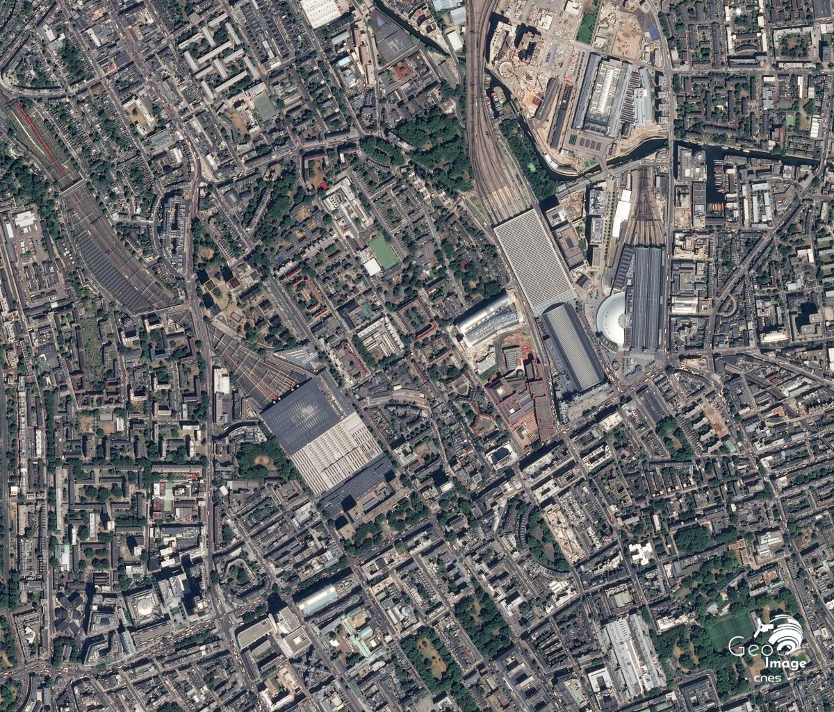
This image covers a suburban area north of the centre of London. This district is relatively isolated from the surrounding neighbourhoods by a double urban cut: an east/west cut linked to the presence of the Euston Station railway lines to the west and King Cross-St Pancras to the east, and a north/south cut consisting of a major road axis, Euston Road/Pentonville Road.
This peri-central district can therefore be considered as an island, a major railway node in the heart of the metropolis and a former industrial hub in full reconversion that must adapt to the rapid sectoral and functional changes in the city’s economy. It is a space where the ambitious policy of the London Municipality of Territorial Development, articulated to that of transport infrastructure, is perfectly illustrated.
One of the capital’s most important communication nodes
The area attractiveness is linked to the presence of three stations: Euston Station, St Pancras Station and King Cross Station. Opened in 1837, Euston Station was London’s first inter-city railway station serving northern England, Scotland, and the west coast. It underwent major renovation work in the 1960s and is now undergoing a major transformation, as it is expected to host the UK’s 2nd high-speed train line from London to Birmingham by 2026.
The St Pancras Station and Kings Cross Station are the largest multimodal passenger hub in central London, connecting 6 metro lines and 17 bus lines. These two major train stations have close to 140,000 passengers a day. It is planned to exceed 60 million passengers per year within a few years.
Indeed, the population and urban growth of London is based on a logic of concentration of employment in the enlarged hyper-centre in the Docklands. Meanwhile the places of residence are becoming increasingly decentralized in the periphery. This process leads to a significant increase in commuting and therefore reinforces the role and place of exchange platforms such as Euston Station and Kings Cross/St Pancras in urban organization.
As you can see in the picture, brownfields are spreading between St Pancras and King Cross. These are crossed by the Regent’s Canal, one of the branches of the Grand Union Canal connecting Birmingham to the city of London and the Thames. Built at the beginning of the 19th century, this canal was a major axis of freight traffic throughout the Industrial Revolution and until World War II when it constituted an alternative to rail transport. Together with the King Cross station, it was thus one of the major lines of communication for the transportation of goods throughout the 19th century and until the aftermath of the Second World War.
Around the station and the canal were then developed large warehouses that hosted all kinds of goods to meet the needs of the London population in the Victorian era: fresh products (fruits, vegetables, fish, etc.) but also large quantities of coal and gas.
A decline and ill-famed district from the 1950s
These warehouses were less and less used in the aftermath of World War II when the road took over from rail freight transport. From the 1970s on, the Kings Cross district became a very unpopular area, a place of all trafficking and major prostitution. The working-class habitats are gradually deteriorating, and the working-class population is experiencing severe impoverishment.
Despite this gradual decline, the district does not belong to the priority axis of urban regeneration of the 1980s, rather centred along the Thames and the former docks around Canary Wharf. It was not until the mid-1990s that the question of its regeneration emerged. The decision to transfer the Eurostar station from Waterloo to St Pancras to allow the construction of the UK’s first high-speed line marks the start of the neighbourhood’s transformation. The opening of the St Pancras International station in 2007 launches more widely the work of profound transformation of the urban fabric.
An ambitious urban regeneration program: enhancing the hub function and renewing economic activities
This peri-central district is now the site of a very ambitious urban regeneration programme based on its hub function. The regeneration perimeter extends over nearly 27 hectares north of the two Kings Cross and St Pancras stations around the Canal. Straddling the two boroughs of Camden and Islington. He obtained a unique postal code, NC1, to symbolically mark the unity of the perimeter.
The developers in charge of regeneration had to commit to building a large residential park, one third of which must be reserved for social housing, schools, and public spaces and to rehabilitate or build nearly 50 buildings intended for economic activities. Thus, at the heart of the perimeter, St Martin’s School, one of the world’s leading schools of architecture, design, and fashion, was established in 2011 in a completely renovated former building that opens onto a square, Granary Square.
This regeneration program is marked by a real desire to preserve the industrial memory of the district. Thus, as can be seen in the picture, three old circular gas reservoirs have been preserved, two have become luxury residences and the third is a public park.
The financing of the project, again based on a public-private partnership, should make it possible to attract investment flows and new businesses. Therefore, two flagship companies, Google, and Facebook, are at the centre of the regeneration project. They must contribute to the economic dynamism of the district by promoting the development of a high-tech hub linked to the creative economy and computer technologies. The aim is to build a link between Silicon Roundabout Tech City UK and King Cross. Today, we are witnessing a complete metamorphosis of the neighbourhood’s image: from a dangerous and ill-known place to one of the new lungs of the world city.
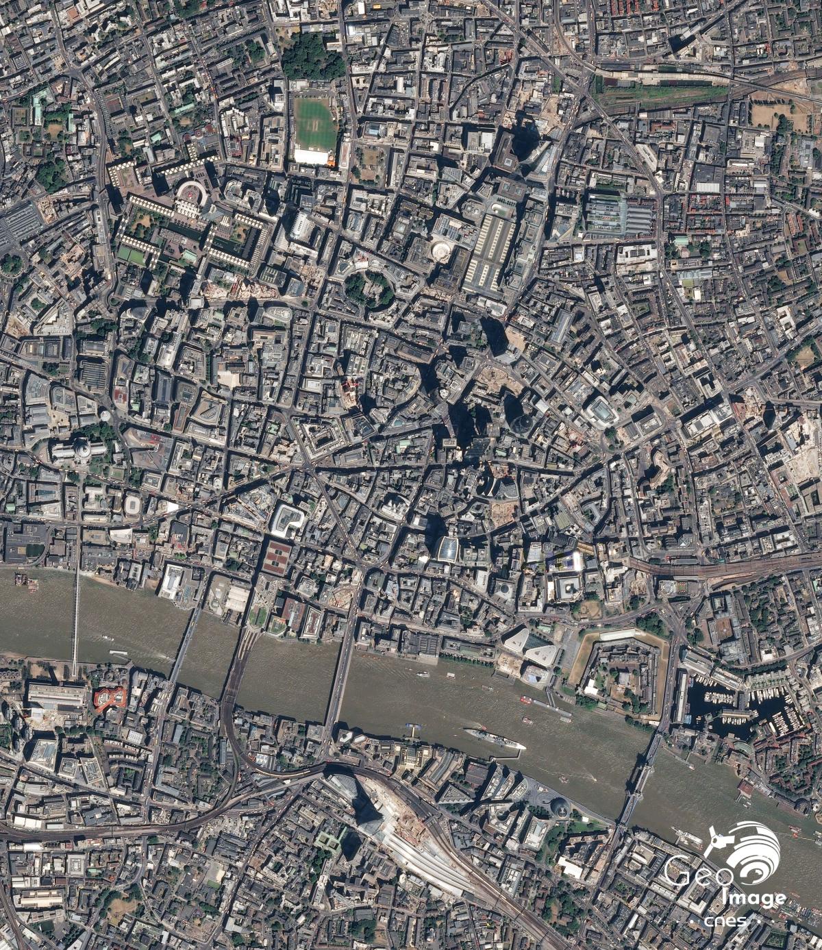
The City : a small territory, financial centre and historic heart of London
Located on the left bank of the River Thames, the City is a small territory of 2.9 km2 delimited to the south by the river. It is the historic heart of London and one of the most powerful financial centres in the world. The City’s modern buildings are adjacent to Roman remains, medieval alleys and churches of the 17th and 18th centuries.
Since the Middle Ages, the City has enjoyed a specific status, giving it real autonomy in management. It is therefore both a county of London and a full-fledged city with its own mayor. Various historical monuments such as the Tower of London, the famous Tower of London in the southwest of the image, and Saint Paul’s Cathedral in the west, also give this territory a strong tourist attraction.
A world financial centre of first order
The City is one of the world’s leading financial centres alongside New York, Tokyo, Shanghai, Paris, and Frankfurt. This business district concentrates financial activities, head offices of large companies, banks, large insurance companies, and a range of business services (law firms, communications, advertising, marketing, etc.)
Despite the financial transactions development via digital networks, the process of globalization has not resulted in a deterritorialization of the economy. Like the Leadenhall Market, a covered market for pubs and restaurants located between the Leadenhall building and the Walkie Talkie, the City remains a place where financiers meet to close deals. This synergy between the various economic agents involved promotes the creation of wealth and explains this high concentration of metropolitan functions.
We can spot on the image some prestigious institutions of global finance. In the extension of the railway bridge, the Bank of England nicknamed the old lady Threadneedle street is the Central Bank of the United Kingdom. Opposite, the Royal Exchange is the City’s first stock exchange founded in 1565. The London Stock Exchange, north of Saint Paul, is one of the largest stock markets in the world alongside the stock exchanges of Tokyo, Shanghai, New York, Paris, and Frankfurt.
Verticalization and urban densification
The vertical cityscape of the City stands in stark contrast to the rest of London, a historically horizontal city consisting mostly of 3- to 4-storey buildings. This landscape contrast is remarkable on the image between the eastern part and the central area of the image.
The construction of glass and steel buildings, usually signed by internationally renowned architectural firms, testify to the urban regeneration and the economic dynamism of the city. This dynamism is linked to the policy of financial deregulation implemented by Margaret Thatcher in the 1980s and to a very advantageous British taxation. Since the 2000s, the City has seen a proliferation of tower projects. This policy responds to the need for urban densification and should strengthen the international stature of cities.
The London skyline is both a manifestation and a symbol of the city’s power, its modernity, and its integration into financial globalization. Although the financial crisis of 2007-2009 has slowed down this construction dynamic, several projects are being carried out. On the image, the Maroon polygons are as many building sites under construction. The large number of cranes that can be seen in the picture also shows this dynamism.
These new towers transform the urban landscape of the city and give it a specific urban signature. From the south to the north of the River Thames, you can see some of the iconic buildings that punctuate London’s urban skyline. At 20 Fenchurch Street, a 160-meter-high building was built between 2009 and 2014, called Walkie-talkie by Londoners because of its specific shape. A little further north, the 234-metre-high Leadenhall Building, designed by architect Richard Rogers, is nicknamed the cheesegrater. It houses business offices.
Its construction was completed in 2014. At 30 St Mary Axe, from the top of these 180 meters, this building signed by Norman Foster was strongly criticized because of its ovoidal shape. It is nicknamed The Gherkin. At 22 Bishop gate, the Pinnacle, 288 metres high, is under construction. Finally, south of the Thames, we can spot the Shard. This 310 m high tower, designed by the architect Renzo Piano in 2014, also sparked controversy. It is at the heart of a Southwark urban renewal project.
A connected district to the rest of the city and the world
The City has a population of only 9,041 residents, but accommodates more than 300,000 people daily, with 3/4 jobs directly related to the City’s financial operations the rest being employees working in support services activities. The importance of commuter shuttles between the City and the rest of London has led the municipality to define as a priority the strengthening of London’s accessibility in the 2004 London Plan.
Many metro stations serve the orbital neighbourhoods of the City to the north, south to the east and west via the stations of Saint Paul, Bank, Monument or Tower Hill, but also the airports of Heathrow and City Airport, out of the picture. Liverpool Street Station, along Bishopsgate, serves Eastern England and Stansted Airport. The City is also served by several bridges crossing the Thames. The Millennium Bridge, Southwark Bridge, London Bridge and Tower Bridge can be identified in the picture from west to east. The first wooden bridge to cross the River Thames in Roman times is the present site of the London Bridge.
Shoreditch, an example of a spatial recomposition north-east of the City
The attractiveness of London translates into an extension of the City to the north and east and a process of gentrification of the Shoreditch district. It is at the interface between the City and the East End of London, two economically and sociologically very distinct territories.
In the north-eastern part of the image, one can identify a habitat consisting of small collectives or buildings. Shoreditch is historically a working-class neighbourhood populated by immigrant populations, especially from India and Bangladesh. The landscape contrast with the City, quite close in terms of distance, is amazing.
The City was extended to the north along Bishopsgate. The Greater London Area Plan aims to strengthen urban densification around transport nodes such as the Liverpool Street Station Building Project. The current urban reconstruction is clearly visible on the image. To the north of Liverpool Street Station, two recent towers can be identified as moving towards Shoreditch, the Bradgate Tower and the Main Tower, scheduled for completion in 2019, followed by another building under construction. On the other side of the street remain houses of 2 to 3 floors old sometimes abandoned and coveted by real estate developers.
This transitional space is the subject of controversy between residents' associations and real estate developers. Thus, the Bishopsgate Goodsyard, a 5-ha derelict railway located in the extreme north-east of the image, is at the heart of a project of extension of the City very contested by the riparian populations. The opening of the Shoreditch High Street station, located along the north side of the derelict Bishopgate Goodsyard, is at the heart of the process of rebuilding the Shoreditch neighbourhood. The station connects the area to the East London Line. Made entirely of concrete, it was built with a view to the future development of the wasteland.
Shoreditch is therefore in the process of being rebuilt under the effect of the extension of the City. Today it is a composite neighbourhood that is becoming gentrified. The high land pressure linked to the proximity of the City led to a rise in land prices, which led to the departure of the smallest populations and a transformation of the functions of the district.
As a sign of this ongoing gentrification, the Old Spitalfields Market, south of the wasteland of Bishopsgate Goodsyard, is a former Victorian supply market transformed into a huge covered market with trendy boutiques and artists. To the east of this market, a former brewery – the Old Truman Brewery – has become a venue for artistic events, bars, and a vintage market. Every weekend, Brick-Lane Market welcomes tourists and the area is now known for its Street Art frescoes.
The City, the financial heart of the city, is a historic district that is experiencing a process of densification, verticalization and extension to nearby territories under the effect of increasing integration into the process of globalization. Like Shoreditch, these dynamics lead to a large-scale urban, economic, and social reconstruction of neighbourhoods.

Additional images
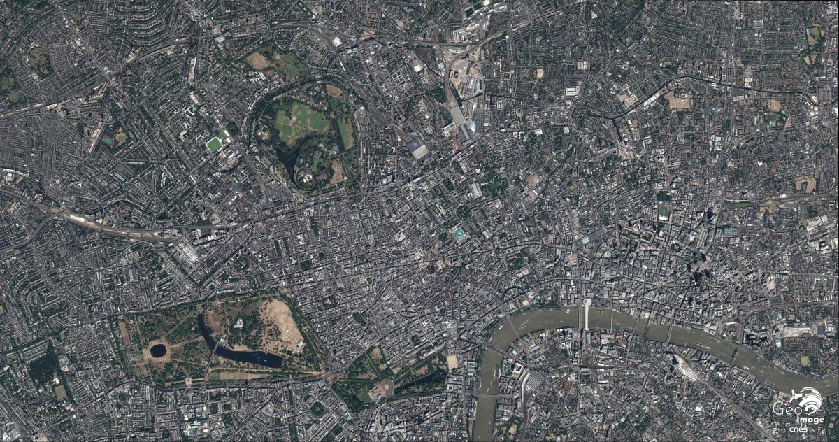
This image was taken by a Pleiades satellite on 3 July 2015. It is a natural colour image with a native resolution of 0.70m, resampled to 0.5m.
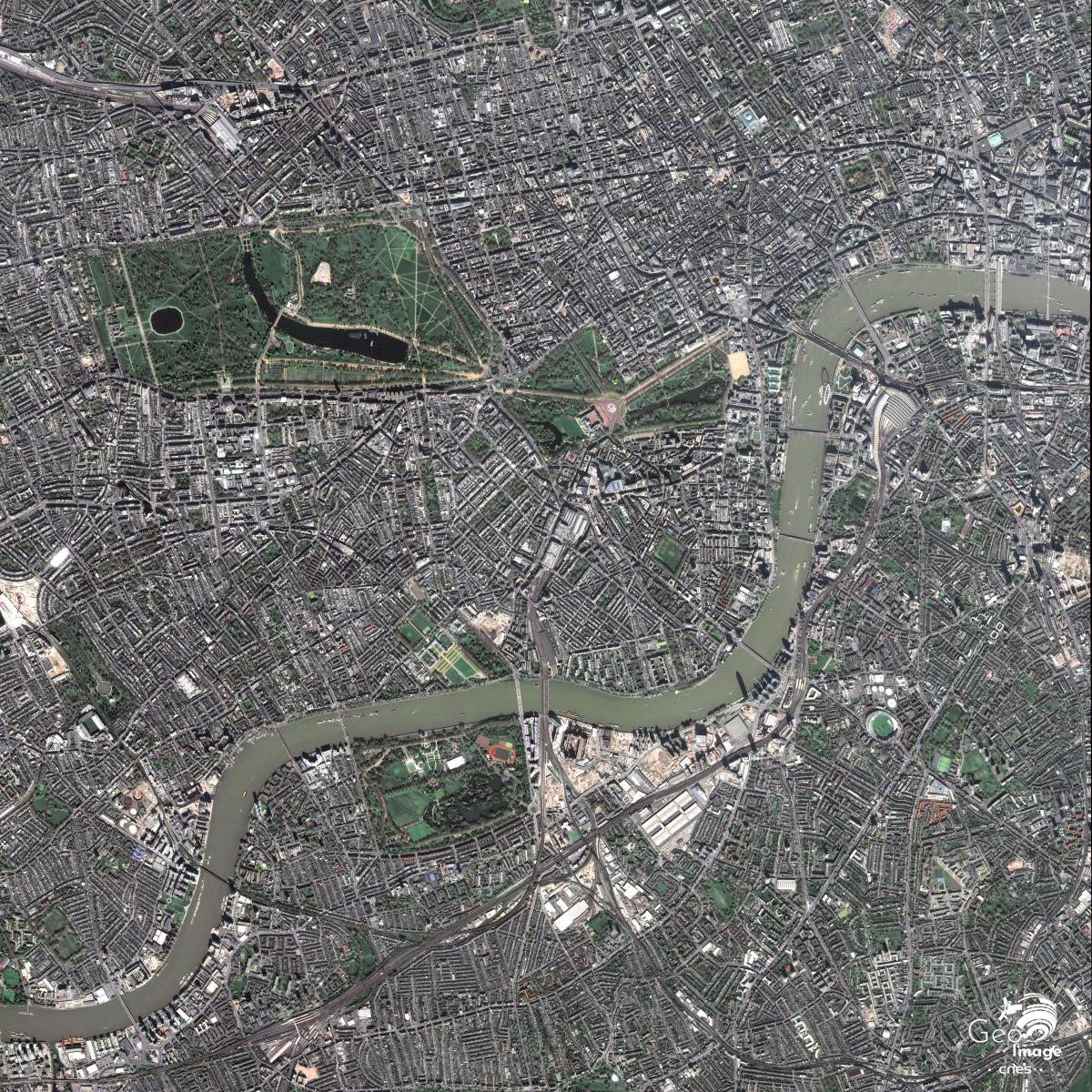
This image was taken by a Pleiades satellite on 8 April July 2017. It is a natural colour image with a native resolution of 0.70m, resampled to 0.5m.
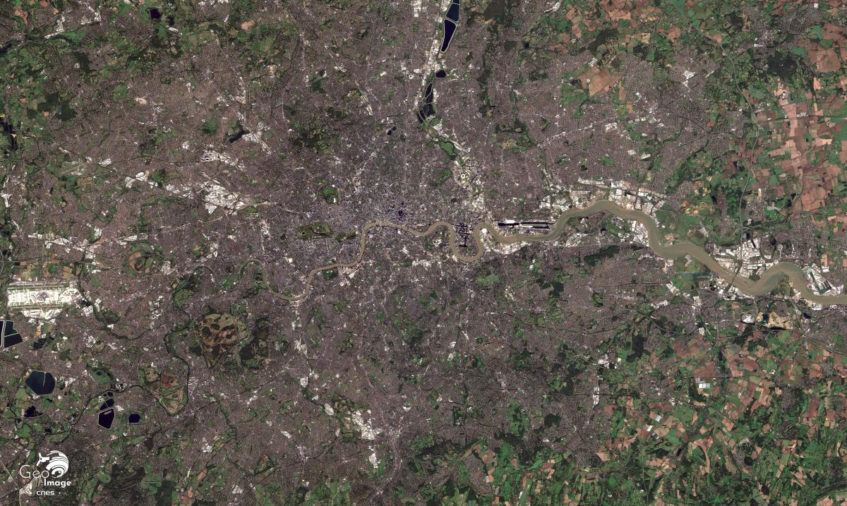
This image of the London region was taken on February 26, 2019, by the Sentinel-2B satellite. It is a natural color image with a 10-meter resolution.
More resources
- Appert, Bailoni, Papin, Atlas de Londres, une métropole en perpétuelle mutation, Autrement, 2012
- Appert, Manuel, et Martine Drozdz. « Conflits d'aménagement aux marges nord-est de la City de Londres », Hérodote, vol. 137, no. 2, 2010, pp. 119-134
- Bethmont Rémy, Histoire de Londres, Tallandier, 2011
Carroué Laurent, La planète financière. Capital, pouvoirs, espace et territoires, collection U, Armand Colin, 2015 - Chassaigne Philippe, Marie-Claude Esposito, Londres la ville-monde, 2013, Vendémiaire
- Manuel Appert, “Londres entre régénération urbaine et verticalisation”, entretien, mondes urbains britanniques, Urbanités, octobre 2014
- Martine Drozdz, “Réparer des marchés défaillants et après ? La régénération urbaine par projets à Londres”, entretien, mondes urbains britanniques, Urbanités, mars 2016
- King’s Cross Visitor Centre
- Site de la ville de Londres. Les grandes opérations de rénovation urbaine
Translator
Christophe Léon, professeur, agrégé, ESPE de Bordeaux
Author
Julien Meynet et Elodie Gruit, Lycée français Charles de Gaulle, Londres

