Between the Hudson River (to the west) and the East River, the southern tip of Manhattan Island is the historic center of New York City, veritable global city, at the heart of the American megalopolis. As often as it's associated with monotony or nonchalance, it's linked to abundance and luxury--New York is a city of contrasts, which is constantly reinventing itself. Inhabited, occupied, while simultaneously engaged in globalized phenomena (economic competition with other global cities and increasing ecological risks also confront it), this space is situated at the junction of global, metropolitan, and local scales and forces. In this context, the city is adapting and transforming itself in response to these stakes, all the while preserving its unique character.
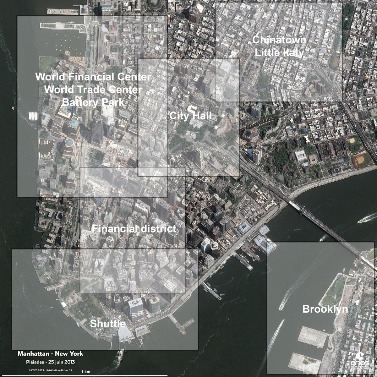
Image information
This image was taken by a Pleiades satellite on 25/06/2013. It is a natural color image, native resolution at 0.70m, re-sampled at 0.5m.
General image without geographical landmarks
Contains information PLEIADES © CNES2013, Distribution Airbus DS, all rights reserved. Commercial use prohibited.
General presentation of the image
Southern Manhattan : Between the Global and the Local -
The transformations of a multifunctional urban space.
A coastal location with unique urban characteristics
"City of hurried and sparkling waters! City of spires and masts! City nested in bays! My city!" The last lines of Walt Whitman's poem "Manhatta" aptly describe the geographical situation of southern Manhattan : "an island of hills" (translation of the Native American name "Manhatta"), nestled in the Lower and Upper Bays of New York and separated by the Narrows. They also describe its situation at the interface of the ocean ("sparkling waters") and the Hudson River ("hurried waters"), as well as it function as a port city ("City of spired and masts").
Resting on a solid metamorphic rock foundation from the Precambrian Era, Lower Manhattan is characterized by a high mineral content and a large degree of artificial modification, according to the satellite image, both for its landmass and its coastal adaptations. It embodies an ideal type of urbanism, of THE city, via the functions that it concentrates and by the images and representations that it generates and continuously renews.
Since the foundation of a commercial outpost (New Amsterdam) by the Dutch, the city has been located along a strategic gateway for merchants interested in trading with North America, at first for beaver pelts in the 17th century, then for tobacco traders, and even for the slave trade. Following the construction of the Erie Canal (1825) and the regulation of the Hudson River (in the West), the city developed a hinterland worthy of it (the Great Plains of the Midwest), which made it into the largest port in the world until the mid-20th century.
In 1818, the city outgrew its narrow network of colonial streets lined with low-rise homes. The city's administration decided to extend its roads along north-south avenues and parallel intersecting streets in a grid-like layout. The urban expansion that followed was swift and extended to adjacent shores in Brooklyn (following the construction of the city's first bridge, the Brooklyn Bridge in 1869), in Staten Island and New Jersey (ferry connections to both) where picturesque farmhouses were rapidly replaced by the horizontal urbanism of suburbs. The development proceeded with the addition of Brooklyn and Staten Island in 1898 to the other boroughs (Queens, Bronx, and Manhattan) in the new metropolis of New York City, which grew to be the second largest city in the world (after London) with 3.5 million residents.
A Polymorphous space reacting to distinct functional needs
Today, one can distinguish schematically several neighborhoods with clearly distinct functions.
In the South is situated the Central Business District or Financial District, which corresponds to the original urban nucleus of Wall Street. It includes City Hall and municipal administration buildings, as well as the rebuilt World Trade Center following the attacks of 9/11 2001. This district has a global financial vocation and is notable for its vertical urban design, thanks to its skyline.
In the Northwest there are shorter building, but with a large footprint on the ground. These are the neighborhoods of Tribeca and Soho, former industrial zones, which were renovated in the 1990s.
Finally, in the Northeast are situated the neighborhoods of Chinatown, Little Italy, and the Lower East Side with even shorter buildings. These are residential structures, which include the historic tenements constructed in the mid-19th century to accommodate successive waves of immigrants. They are currently in the process of gentrification.
The Center of a World Class City : A Concentration of Decision-Making Bodies
Lower Manhattan, as it's presented here, represents a microcosm of the global city of the New York metropole. It concentrates the functions of decision-making bodies that interact on both the local and global scales. On the satellite image one notices the New York Stock Exchange (NYSE, "Wall Street") at the heart of the Financial District. The NYSE composes the largest financial market that influences all global stock markets. On the south bank one can make out the city's famous skyline, which is the city's trademark landscape, a component of its identity, which reflects its economic power, since it is the site of the headquarters of the largest American companies (including AIG, American Express, and others) with a global presence.
Slightly to the north, near City Hall is the Civic Center, which incorporates the city's municipal buildings. On the political front, note that City Hall, then Fraunces' Tavern, and finally Federal Hall located on Wall Street, served as the provisional capital of the United States from 1785-1789. George Washington was sworn in at Federal Hall as the country's first president. Finally, Lower Manhattan is a center of learning and knowledge creation around the campus of Pace University; it is also a major tourist destination in New York.
A connected neighborhood - linked to the network of international decision-making.
This image renders visible the wide diversity of communications vectors that criss-cross the city and give it "hyper-spatiality": a ferry links to the five boroughs and New Jersey, bridges (Brooklyn and Manhattan Bridges), peripheral highway, tunnels, train station (Transportation Hub designed by the architect Santiago Calatrava), heliports, and multiple subway lines.
More broadly, New York and its bay are an area where air transport and maritime flows are concentrated (first port on the Atlantic façade of the United States), which contributes to connecting the city to the rest of the world. It is also home to the world's most important digital data network, which allows the city to steer the world's financial networks and develop a tech sector for its own hi-tech economy.
Detailed images
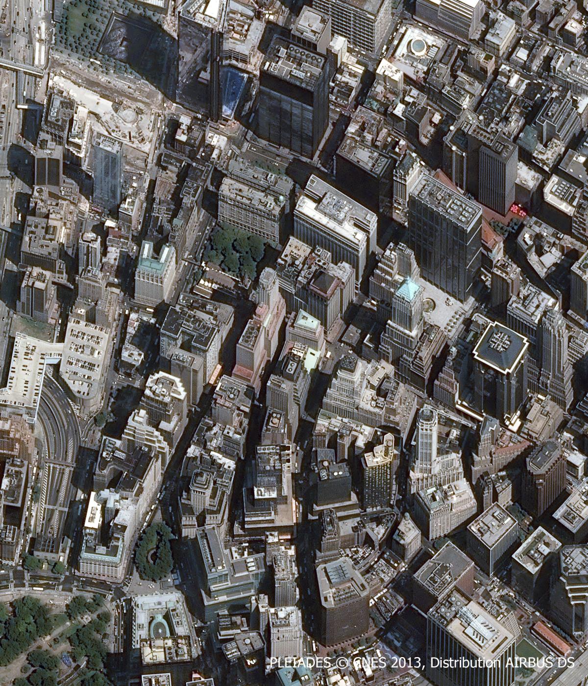
WALL STREET
"It was standing tall, their city, straight up. New York is a city that is standing up," marveled Ferdinand Bardamu, the protagonist of Louis Ferdinand Céline's Journey to the End of the Night, when he arrived by ship in New York Harbor. Indeed, this close-up of the Wall Street district at the south end of Manhattan Island shows numerous buildings that are awe-inspiring with their stature, their gigantic scale and their modernity, which give the impression of vertigo and convey strength. Their varied architecture gives the effect of a site undergoing continuous construction and regular renewal. The image also highlights an irregular pattern of streets whose narrowness is reinforced by the height of massive, adjacent buildings and the absence of sunlight. In some corners, you'll notice parks, green spaces, cemeteries or squares. Originating from Bowling Green Park in the south, Broadway crosses the image from South to North.
A Long History largely associated with the rising power of the United States in the world
We are at the heart of colonial New York, founded by the English in 1664 on the site of Dutch New Amsterdam. The city was a modest trading post at the time with bucolic references to the topographic features (Cedar St., Pine St.) and protected by a palisade that designated its border (Wall St.). The beaver trade (Beaver St.) was a form of interaction with Native American tribes. Vestiges of this period include churches, such as Trinity Church (in the center upper left of the image), surrounded by an English-style cemetery to the north and south, and Federal Hall (1703).
The invention of the elevator in New York (in 1857) combined with the birth of the skyscraper in Chicago (in 1881) to transform the southern tip of the city into a perpetual construction site where office towers rival each other in terms of height and with respect to innovative design to create a daring skyline. A symbol of the power with which the city is aligned, New York is a model for other business districts around the world. Although Federal Hall on Wall St. reminds us that the city was the ephemeral political capital of the country (1785-1790), it was due to its financial activities that the city owes its dynamism.
These investments included loans to English privateers during the Seven Years War for control of Canada (1756-1763), the financing of the slave trade for tobacco plantations as well as for local labor markets (at the end of the 17th century there were a dozen slave markets on Wall St.), major urban projects at the beginning of the 19th century (construction of the street grid), and the financing of the Erie Canal to extend the hinterland from New York to the Great Lakes region.
A Central role in financial activities
Lower Manhattan has remained a cosmopolitan neighborhood with a marked Protestant ethic (see the churches on the image with their significant real estate holdings). The Financial District is the site of the Federal Reserve Bank of the State of New York (on Liberty St. since 1924), major private banks (Chase, Morgan, HSBC, Deutsche Bank), courts, currency trading offices, major corporations (Standard Oil in the past; Condé Nast, AOL, Spotify today), as well as the New York Stock Exchange (Wall Street stock market) all integrated into networks. Wall Street remains the largest stock market in the world based on value; however, it is mostly an empty shell today.
The deregulation of financial services in the 1980s led to digitizing most of the trading (on market floors), which required larger platforms and contributed to relocations (Midtown to Times Square or in the greater metropolitan area (Connecticut or New Jersey). Adding to this decline has been the competition from other global cities with the result being that the Central Business District of Lower Manhattan is merely the fourth largest in the country.
Tourism, Symbols and Political Space
Despite losing ground in economic terms, the Financial District continues to convey a powerful representation in the collective urban imagination related to an event (the crash of 1929) or linked to a cliché (power, the clout of money, symbolized by the bull statue on Bowling Green) that many tourists seek out in a shared experience of waiting in line to take a photo (of the Wall St. bull or the façade of the stock exchange on Wall St.), or by attending large parades along the Canyon of Heroes on the southern stretch of Broadway.
On the other hand, this same space may also be a site for contesting globalization or alternatives to globalization appropriated by individuals protesting a globalized world dominated by financial corporations and banks (for example the Occupy Wall St. movement), or to challenge national politics (protests in Battery Park), or to call into question values that appear outdated (such as in the statue of the young girl opposite the Wall St. bull to denounce the inferior status of women in corporations and society in general).
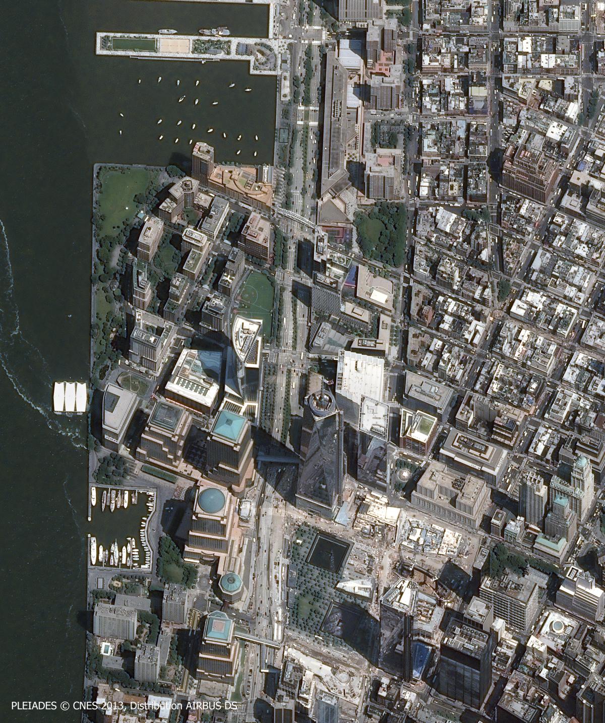
WORLD TRADE CENTER ET BATTERY PARK
This close-up of the extreme Southwest of Manhattan encompasses two spaces: the World Trade Center on the right and Battery Park City on the left, separated by a six-lane highway (West Street, which is parallel to a bicycle lane).
The World Trade Center, from the attacks of 9/11 to its reconstruction
The attacks of September 11, 2001 and the destruction of the Twin Towers of the World Trade Center transformed the urban landscape of southern Manhattan. They also made the WTC a "place-event" inaugurating a new form of terrorism that provoked a traumatic experience for New Yorkers and an unprecedented emotional response from people around the world.
The satellite image reveals a neighborhood under construction on the right with scars covering its wounds. A modern new tower, One World Trade Center, is the tallest building in the United States in 2018 marks the renewal and American national pride restored : symbolically is is 1776 feet tall, corresponding to the date the American colonies declared their independence. Beside it, two construction sites indicate two more towers are being erected. On the site of the destroyed Twin Towers lies a memorial situated in their footprints to remind visitors of their destruction by their absence. Finally, a new train station-the White Oculus designed by Santiago Calatrava--which serves as a shopping center and contains a museum as well.
As geographer Catherine Pouzoulet showed, the rebuilding of a site is linked to many factors, both in urban policy choices and in terms of symbolism. The project that was executed aims to conserve a sacred character for this place, to ensure it remains a realm of memory over the long-term. These memories are dear to New Yorkers; they are conserved by preserving the Towers' foundation walls, the esplanade, and the memorial garden. But the site also carries a cultural, artistic dimension and is a popular destination for tourists (9/11 Memorial Museum, arts works, modernist architecture in train station). Moreover, it maintains its economic and functional rationale to ensure its profitability / economic viability to regain high density, vertical construction with a tight connection to surrounding suburbs in New Jersey with its rail network and commercial objectives (shopping mall).
The forces that intersect at Ground zero illustrate the essence of what Michel Lussault calls a "hyper-place." Here the dialectic of forces plays out between the tensions pulling a place between the local (a desire for sacred space) and the global (to accentuate the CBD or New York's Financial District).
Battery Park City: Urban and Functional Reorganization and Management of Flood Risks
Battery Park City, on the left of the image, is an artificially constructed space, landfill that was developed, thus extending the island into the Hudson River. The neighborhood appears to be a model town where residential buildings, malls, movie theaters, green spaces, and gardens (upper left), small sailing port (extreme left), baseball diamond, etc. The neighborhood invites tourists to stroll along the port, to seat on the terrace, and to take photos of souvenir segments of the Berlin Wall.
This residential neighborhood is located on the site of former quays and docks of Lower Manhattan. Climate change in the form of rising sea levels and the growing number of intense hurricanes (such as Superstorm Sandy in 2012) present new ecological risks : flooding, destruction of roads, flooding of tunnels. These threats render the neighborhood particularly vulnerable. To combat these risks, the city has launched a policy of reclaiming the banks of Battery Park by making them pedestrian walkways by constructing a promenade and a park thereby reducing the sector's vulnerability. At the same time, "green" building standards are being required to new buildings under construction in the area with green roofs installed (such as The Solair building visible in the upper left of the image) to fight against climate change.
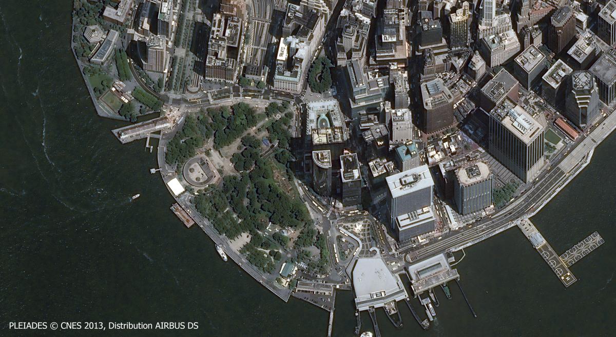
SOUTHERN TIP TOWARD THE STATUE OF LIBERTY AND STATEN ISLAND
At the southern tip of the island, Battery Park and its neighborhood are laden with history, since these areas have always served as an interface between New York Harbor (and beyond to the Atlantic Ocean and to the world at large) and the city (and beyond to the rest of the American continent). Paul Morand wrote about Bowling Green Park--the city's oldest park situated in the extreme north of the image--that it was the city's "matrix" from which Broadway emerges "like a bulb." This street is the axon of a synapse composed of three spaces.
Three types of spaces, three complementary functions
To the West a park surrounds a round structure. This is Battery Park where an artillery battery was constructed in the 17th century. All that rests is the annex, built after the American Revolution--Fort Clinton. The park is composed of thickets, small lawns, cafés along terraces, but also a vegetable garden and small squares. Numerous pedestrian pathways and a bike trail criss-cross the park conveying its recreational purpose as opposed to the highway that passes under the park and emerges to the North (Northwest corner). On the banks there are ships. A clipper recalls the colonial period and ties to Europe. To the south of the park the building with a white roof houses the Coast Guard, which provides security for the city's waterfront.
To the north and to the east, tall buildings signal the southern part of the Wall St. district. They manifest a transition with commercial functions and the development of the financial sector; an example is the Cunard Building--office towers of the famous British sailing company, which were bought by the well-known financial ratings agency Standard & Poors. At the upper center of the image customs buildings are visible in the shape of an inverted "U"; their function was to levy taxes on goods passing through.
Finally to the south are terminals, ships, and the sea, all of which constitute a full-fledged space insofar as the "sea around New York is as inhabited as the land," to quote Paul Morand. The terminal on the left is larger and more modern plays an important role with 70,000 passengers transiting through it on their commute to work to southern Manhattan and beyond from Staten Island. In November tens of thousands of marathoners begin one of the world's most famous races in Staten Island each year. The terminal on the right is the Battery Maritime Building. More modest and older (it appears sheathed in steel armor), it constituted an industrial wasteland that has been transformed today into non-industrial use.
A Symbol of the Symbiosis between the town and the sea
Everything in this image symbolizes the symbiotic relations between the existing city and the sea: from the aquarium located in the center of the park to the sailors from the merchant marine who have a memorial located on the far left; from the former customs house in the middle to the buildings housing the maritime companies to the clippers to the Staten Island Ferry and passing the tourist cruise ships heading for the Statue of Liberty. This image translates commerce trade and circulation.
Following the American Revolution, the city grew beyond its walls little by little and gradually abandoned its military defence complex while shifting policy from a policy of closures to a policy of opening-up. As an economic opening, commercial port activity that has recently been transferred to New Jersey. Across the Harbor, but still visible from Battery Park they continue to make New York a major port on the Atlantic sea bord. It signalled a migratory opening by welcoming immigrants and exiles from the entire world under the gaze of the Statue of Liberty (1886) to Castle Clinton at first from 1855 to 1890, then to Ellis Island until 1954.
Interactions and multimodal exchanges with the city's other boroughs include: a vehicle tunnel to Brooklyn, ferry to Staten Island, subway and train. These transportation means promote urban sprawl, the displacement of the port, and a functional specialization that has been increasing and renewing neighborhoods.
A sign of American naval power politics, the country was also involved in global wars with memorials to the fallen soldiers of World War II in the Atlantic situated in Battery Park. Another memorial to the victims of the Vietnam War is at the bottom right. Always protecting its strategic interests along the Atlantic Coast, the US exercises power through the presence of a Coast Guard base (white rectangle south of Battery Park), which constitutes a full-fledged and vast American military branch beside the US Navy, the US Air Force, and the Marine Corps, and the US Army.
Today this southern tip of Manhattan is designed to attract tourism and is the object of a policy of urban renewal and reappropriation of the waterfront to permit residents to access to the coast. An urban farm was modernized in Battery Park (noticeable by its horizontal stripes). Along the docks the former Battery Maritime Building was redeveloped. It currently transports tourists and New Yorkers to Governor's Island (non visible in the photo), which has been accessible since 2003. Major redevelopment of the island has transformed its purpose from a former Coast Guard base (construction of bicycle paths, food trucks, museum tours, urban farming, and music festivals).
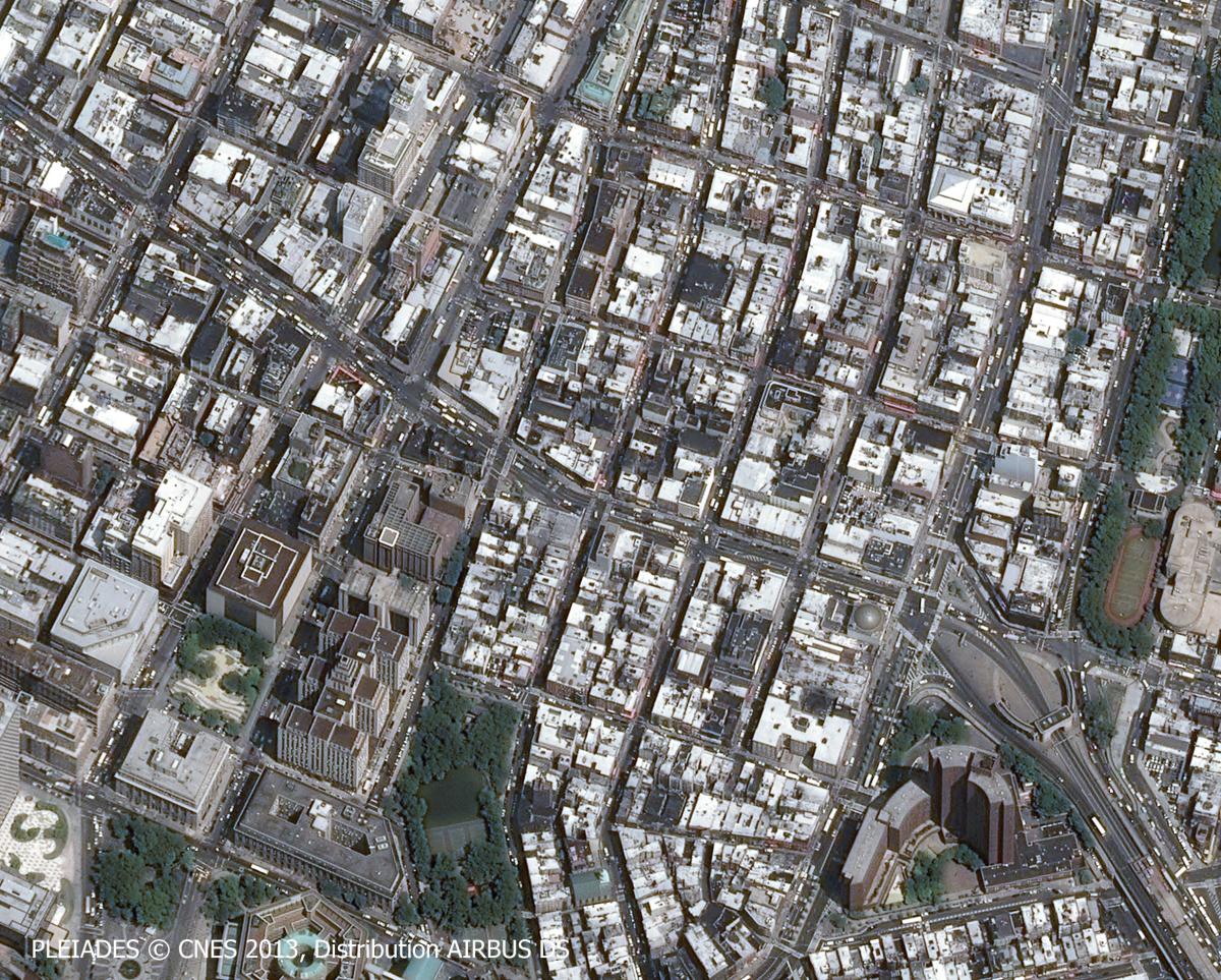
CHINATOWN ET LITTLE ITALY
"Can one know the universe? My God, it's already difficult to find your way in Chinatown" (Woody Allen, Getting Even, 1971). In one of the best-known quotes from the New York film maker Woody Allen one imagines the bubbling and confusing atmosphere of one of New York's most diverse and industrious neighborhoods of Manhattan.
From Little Italy to Chinatown : transformation in international migrations
The neighborhood represented in the image is West Chinatown, which includes the Chinese quarter, the southern section of Little Italy at the extreme northern edge of the image, and the historic district of Five Points at the southern edge of the photo. It contains 100,000 inhabitants of Chinese nationality, almost 80 % of the neighborhood, which represents one of the highest concentrations of the Chinese diaspora outside Asia, whereas the former Italian section--Littly Italy--is home to a minority of descendants of Italian immigrants. This inverse evolution in ethnic populations occurs in a tight area over the course of two centuries of history and American migration policy in New York.
South of Canal Street west of the Manhattan Bridge is shaped like an oblong island with irregular, curved streets, both narrow and dark which poorly integrates into its grid system, which on the other hand represents a regular, right-angled network of streets and avenues established in 1811. We are looking at the historic district of Five Points. There, at the beginning of the nineteenth century, was a marshy, mosquito infested slum that was polluted by the waste and run-off from local factories. Its residents were the poorest immigrants, especially the Irish fleeing the Great Potato Famine (1845-1852). These people lived precariously (high unemployment, rampant diseases, high infant mortality, violence) as described by Martin Scorcese in his film The Gangs of New York (2002).
However, far from being an enclave purely marred by violence, Five Points was also one of the first melting pots in the United States where African, English, Irish, then later Jewish and Italian cultures encountered one another and interacted generating shared cultural practices and common political engagements. In the 1880s the city decided to demolish the slum with the support of hygienic theories (draining marshes, constructing parks) to maintain social control over "dangerous" classes : with the construction of modern administrative buildings such as courthouses (Supreme Court with its panopticon form at the bottom) and prisons (to the West of the old district).
Tenements : buildings with collective rapport - the epitome of New York
To the North of Canal Street a more regular urban design appears. It includes tenements, buildings with collective rapports and symbols of New York. Photographer Jacob Riis, in his book How the Other Half Lives (1890), described tenements to alert public opinion about the problems of misery and overpopulation. These tenements fulfilled a need--to welcome and house a growing number of immigrants. The 1880s marked the high point of European immigration to the United States. At the beginning of the 20th century, immigration was dominated by Italians, who settled around Canal Street--that is throughout the area on either side of Canal St., then followed by Central and Eastern European immigrants. East European Jews were an important immigrant group on the Lower East Side.
This massive influx was accompanied by complex systems of ethnic and racial segregation, which resulted in intentional actes of discrimination, discriminatory structural economic forces and the outcome of individual choices, as demonstrated by the work of geographer Sonia Lehman-Frich. At its height in 1910, the neighborhood numbered 10,000 Italians. They recreated in America a Neapolitant community with their own language, customs, restaurants, cultural, financial, and religious institutions and cultural practices, such as the Feast of San Gennaro, the patron saint of Naples, as well as an active branch of the mafia.
Chinese immigration is more recent. It was restricted due to racist laws, such as the Chinese Exclusion Act of 1882. It was only after the Immigration and Nationality Act of 1965 passed by President Lyndon B. Johnson during the civil rights movement's heyday for Chinese immigration to amplify. The immigrants tended to be Cantonese refugees fleeing the Maoist dictatorship or from Hong Kong. The new arrivals settled in Little Italy and the Lower East Side as these neighborhoods were left behind by upwardly mobile residents. Like the Italians who preceded them, the Chinese immigrants recreated political and community-based associations (Tongs), cultural sites and places for socializing.
The process of gentrification and the mobility of Chinatown in New York
Today Little Italy has lost its charm. The restaurants and shops are merely the superficial appearance of a neighborhood that no longer includes very many Italians. The Chinese section is still vibrant and hectic with a large Chinese population. But for how much longer will this be the case ?
In fact, Chinatown is experiencing gentrification little by little. To the northwest, the trendy neighborhood of Soho is expanding with luxury buildings increasingly going up. To the southwest near the bridge, one notices new building projects are going up on the former sites of run-down apartment buildings. This gentrification generates economic and cultural diversification. But in a working-class neighborhood of tenement buildings, the process also pushes more and more Asians towards outlying satellite Chinatowns, such as in Queens.
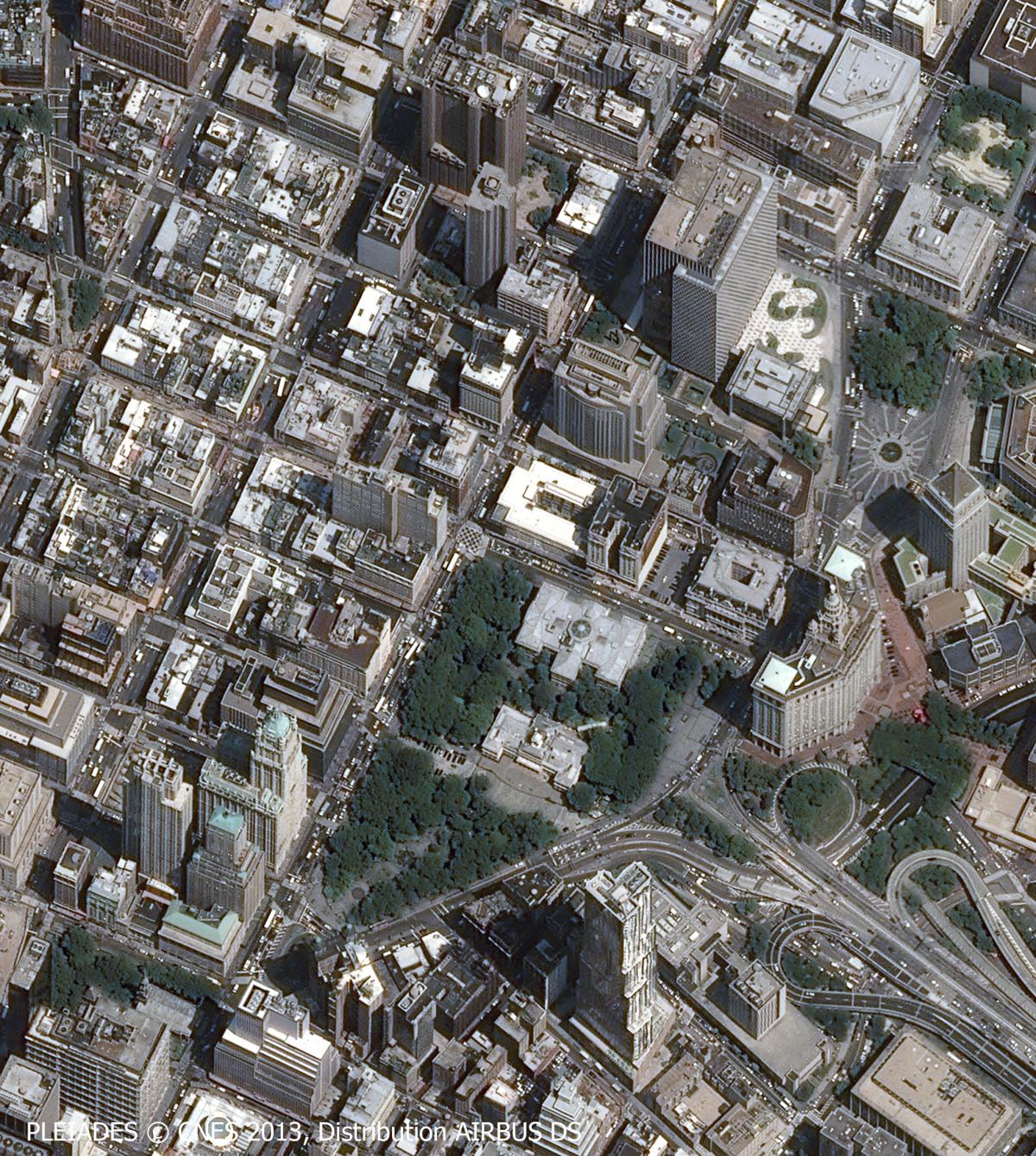
THE SEATS OF POWER : CITY HALL AND COURTHOUSES
New York's City Hall is a white pavillon in the Georgian style capped with a rotunda in the midst of City Hall Park. It is one of the oldest municipal buildings still in activity in the United States. The mayor's offices are located here and marriages are officiated on this site. Municipal administrative functions are housed in the Manhattan Municipal Building, a towering, arched skyscraper on the right of the image. At the top of the photo, a massive modernist building dominates the square--this is Federal Plaza. It houses several federal agencies including the FBI, Immigration and Naturalization Service, and Homeland Security. To the north in the corner of the photo one notices several courthourses (civil court, family court, etc.).
This Civic Center appears as a seat of power where local and federal administrations govern side by side. But there are also media outlets and numerous press groups found here. This power is due to the polarizing dimensions of this space. It is an important rail hub. The first subway station in New York opened here in 1907 on the City Hall-Kingsbridge Line. It is criss-crossed by boulevards, access roads, and exit ramps that are the legacy of modern urbanism designed by Robert Moses, who transformed New York following the instructions of Mayor Laguardia in the 1930s. He drew inspiration from social and progressive concepts incarnated in functionalist urbanism, to the detriment of aesthetic characteristics or the quality of life.
This neighborhood can be considered as the epitome of the city and its excesses in a modern Metropolis, both corrupt (by the shady relationship between urbanism, justice, and politics) and alienating for humanity (due to the subway, the car, surrounding prisons, and the lack of nature). It was a source of inspiration for Gotham City in the Batman comic and film franchise.
Nonetheless this scraped up, transformed, and homogenized space also gave rise to unexpected discoveries and to curious reprises of local, metropolitan, and national history. Thus as the beginning of the 1990s, the remains of 400 African slaves were exhumed from the cemetery that had been left them outside Wall Street, hearkened back to the past, slavery, and segregation in New York. One can observe a small green spot on the image between City Hall and Federal Plaza, which attests to the success of popular pressure to preserve and classify the site as a national monument with its own Memorial: "The African Burial Ground."
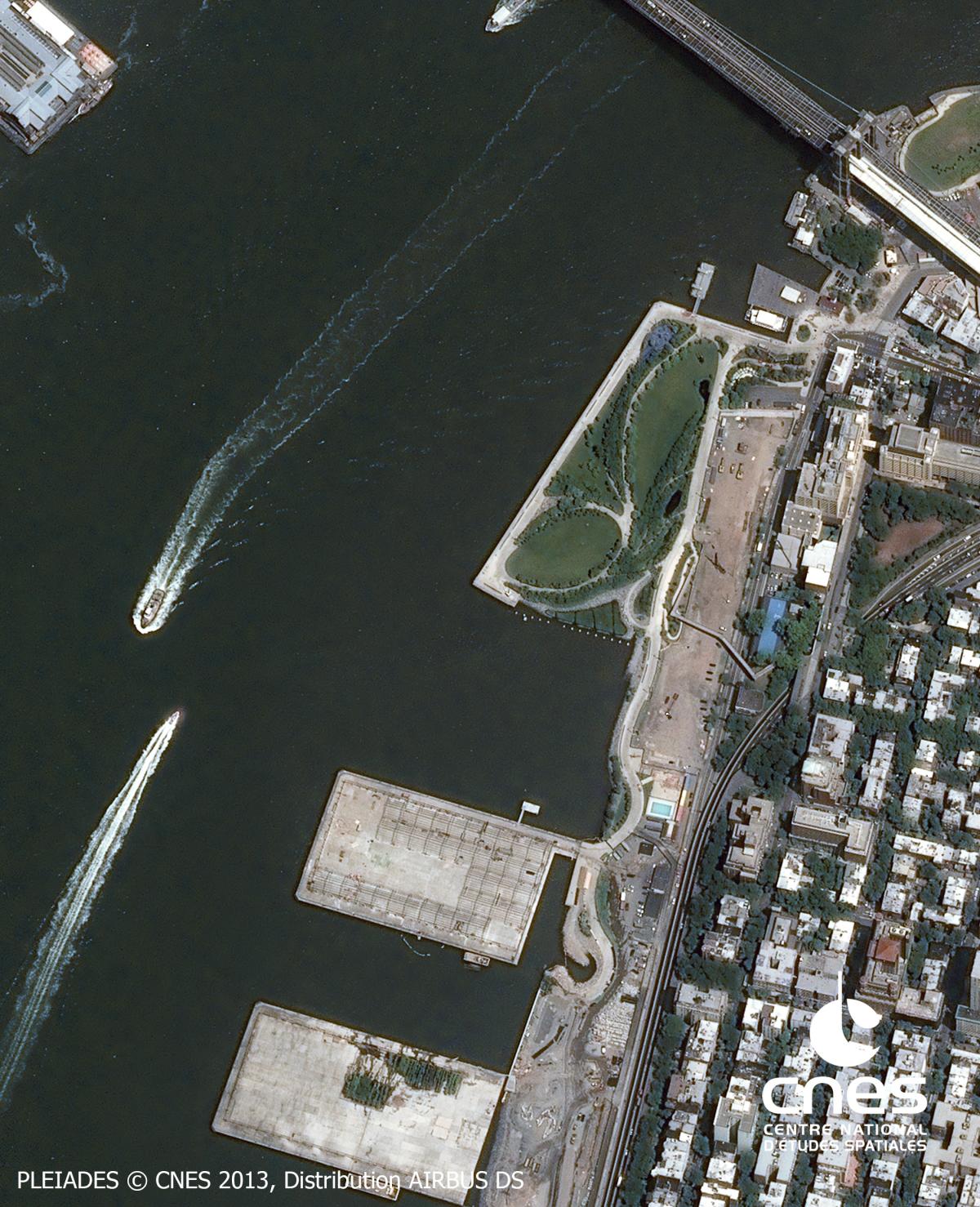
BROOKLYN : A NEIGHBORHOOD WITH PROFOUND URBAN RECASTING
This satellite photo covers a portion of the borough of Brooklyn (Kings County). We are in Brooklyn Heights to the southeast of Manhattan, across the East River on Long Island. Two spaces, separated by highways, appear distinctly: to the north and west a coastal zone with its artificial shoreline signals its former industrial uses; in the middle is situated a residential neighborhood where homes and green spaces are interspersed as in suburbs.
Warehouses: underutilized spaces and urban renewal
To the north of the Brooklyn Bridge there are the vestiges of old warehouses. They were lined along the shore and served to stockpile goods, such as sugar, tea, coffee, alcohol, etc. These goods were delivered by ship before being ferried across the river to Manhattan by local boats. These stores were complemented by processing factories (coffee bean roasting, sugar refinery, and cardboard box production for example). They constituted an industrial fortress of bricks and mortar linked by cobblestone streets crisscrossed by rail lines.
In the 1950s the transformation of global maritime trade led to profound urban changes and how cities functioned. To the south of the Brooklyn Bridge, the coastline will be modernized with the construction of extended piers to attract (without much success) larger vessels. The northside of the bridge is left with industrial wasteland before experiencing a spectacular rebound in the 1980s. Renamed "DUMBO" par an adept urban marketer, it attracts art galleries, theaters, and startup companies in its stylishly renovated factory sites. It was only recently that the coastline in the west of this photo was restored with green spaces and recreational opportunities on its embankments.
Integration at the Margins: a laboratory for North American suburbs
Behind the coastline one finds the neighborhood of Brooklyn Heights. It owes its development as much to the birth of the steam-powered ferry (linking the village of Brooklyn to Manhattan in 1814), which encouraged urbanization, as it does to the investments of the creator and promoteur, Henry Pierrepont. He envisioned the development of one of the earliest bedroom communities (suburbs) here.
The neighborhood had several dozen homes in the 19th century before expanding to over 600 units in 1860 then covering the entire district shortly after the opening of the Brooklyn Bridge. Prior to the Civil War (1861-1865) it was a hub for the abolitionist movement in the vicinity of Plymouth Church, which was a key transit point in the Underground Railroad by welcoming black slaves fleeing the South, by helping them as they headed for Canada. The neighborhood is chic and exercised a cultural role by attracting artists and writers, such as WEB Dubois, Walt Whitman, Arthur Miller, and Truman Capote.
At one point the neighborhood was threatened by the development of towers seen on the right of the image, but today Brooklyn Heights is preserved and maintains its tree-lined promenades giving it a bucolic charm. It epitomizes American suburbs considered a space of social harmony. According to a post-Jeffersonian ideal, the suburbs surpassed the "traditional city-country dichotomy" to convey quintessential spiritual, moral, religious, and social values that the United States was founded upon.
Further resources
- Le Goix Renaud : New York, collection Atlas Mégalopoles, Autrement, Paris, 2009.
- Lussault Michel, Hyper-lieux, Paris, Seuil, 2017
- Pouzoulet Catherine, Enjeu culturel et nouvelles politiques urbaines: l’exemple de New York, de Time Square à Ground Zero, Villes en Parallèle, 2004
- Whitman Walt, Leave of Grass, Penguin Classics, 1961
Author
Jean-Louis Bonnaure and Arthur Plaza, Lycée Francais de New York

