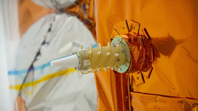
The DORIS system (Doppler Orbitography and Radiopositioning Integrated by Satellite), developed by CNES in the 1980s, is able to pinpoint anywhere on Earth with centimetre accuracy and precisely determine satellite orbits.
Key information
| Mission | Orbit determination and ground positioning with centimetre accuracy, for altimetry, orbit determination and location missions |
|---|---|
| Domain | Earth observation |
| First launch | 22 January 1990 (on SPOT 2) |
| Partners | GRGS, IGN |
| Carriers | SPOT, Envisat, Jason1-2-3, Pleiades, SARAL, CryoSat-2, Sentinel-3A & 3B, Sentinel-6A, HY2A-C-D, SWOT |
| Lifetime | Indefinite |
| Status | In operation |
Key figures
- 20 satellites carrying DORIS
Key milestones
- 16 December 2022: DORIS instrument launched on SWOT satellite
- 19 May 2021: DORIS instrument launched on HY-2D satellite
- 21 November 2020: DORIS instrument launched on Sentinel-6A/Jason-CS satellite
- 21 September 2020: DORIS instrument launched on HY-2C satellite
- 25 April 2018: DORIS instrument launched on Sentinel-3B satellite
- 16 February 2016: DORIS instrument launched on Sentinel-3A satellite
- 17 January 2016: DORIS instrument launched on Jason-3 satellite
- 25 February 2013: DORIS instrument launched on SARAL/AltiKa satellite
- 2 December 2012: DORIS instrument launched on Pleiades-1B satellite
- 16 December 2011: DORIS instrument launched on Pleiades-1A satellite
- 15 August 2011: DORIS instrument launched on HY-2A satellite
- 8 April 2010: DORIS instrument launched on Cryosat-2 satellite
- 20 June 2008: DORIS instrument launched on Jason-2 satellite
- 3 May 2002: DORIS instrument launched on SPOT-5 satellite
- 1 March 2002: DORIS instrument launched on Envisat satellite
- 7 December 2001: DORIS instrument launched on Jason-1 satellite
- 23 March 1998: DORIS instrument launched on SPOT-4 satellite
- 26 September 1993: DORIS instrument launched on SPOT-3 satellite
- 10 August 1992: DORIS instrument launched on TOPEX/Poseidon satellite
- 22 January 1990: DORIS instrument launched on SPOT-2 satellite
- 1980: DORIS system developed by CNES, IGN, GRGS and industry
Project in brief
Developed in the 1980s by CNES in partnership with the French space geodesy research centre GRGS and the French mapping, survey and forestry agency IGN, the DORIS system performs two functions. First, it determines satellite orbits with centimetre accuracy thanks to a network of 60 ground stations around the globe. Second, it is able to calculate the position of any point on Earth’s surface with the same degree of precision. Such pinpoint accuracy serves many applications, like for example the ability to measure variations in sea level or ice sheet height, to monitor ground displacement, to gauge continental drift or precisely locate orbiting satellites.
The DORIS system relies on the well-known Doppler effect, a phenomenon we perceive when the pitch of a siren on a vehicle gets higher as it approaches and then lower as it moves away. DORIS employs the same principle to locate the position of an object emitting radio waves. Data collected by DORIS are processed by the SSALTO multimission ground segment in Toulouse, developed by CNES. DORIS was tested for the first time on the SPOT 2 satellite launched on 22 January 1990.
Since then, the system has flown on many more satellites, including Envisat and the Jason, Pleiades, Sentinel and SWOT series:
- SPOT 2, 3, 4, 5
- TOPEX/Poseidon
- Jason-1, 2, 3
- Envisat
- CryoSat-2
- SARAL
- Pleiades A & B
- HY-2A, 2C, 2D
- Sentinel-3A & 3B
- Sentinel-6A
- SWOT
CNES’s role
The DORIS system was developed by CNES in partnership with the French space geodesy research centre GRGS and the French mapping, survey and forestry agency IGN.
Contacts CNES
Project Leader
Olivier Dumond
E-mail: olivier.dumond at cnes.fr
Operations Project Leader
François Didelot
E-mail: francois.didelot at cnes.fr
Internal Geophysics, Geodynamics and Geodesy subject matter expert
Félix Perosanz
E-mail: felix.perosanz at cnes.fr


