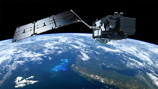
The “Swiss army knives” of space-based Earth observation, the two Sentinel-3 satellites (S3A & S3B) acquire a diverse range of data on oceans and land surfaces, from surface temperatures and heights of seas and major lakes to ice thickness and ocean colour.
Key information
| Mission | Earth observation |
|---|---|
| Domain | Earth observation |
| Launch date | First satellite launched 16 February 2016 |
| Partners | ESA, Eumetsat, European Union |
| Where | 814-km polar orbit, inclined 98.65° |
| Lifetime | 7½ years with option for extension |
| Status | In operation |
Key figures
- 1,250 kg: mass of each satellite
- 1-km spatial resolution (SLSTR sensor)
- 21 spectral bands (OLCI sensor)
- 100 firms in consortium that designed and built the satellites
Key milestones
- Q3 2026: Scheduled launch of Sentinel-3C to take over from Sentinel-3A, in service since 2016
- 25 April 2018: Sentinel-3B launched by Rockot
- 16 February 2016: Sentinel-3A launched by Rockot
- 2014: Copernicus enters operational phase
- 2012: GMES initiative renamed Copernicus
- 2001: EU and ESA launch Global Monitoring for Environment and Security initiative (GMES)
- 1998: Baveno Manifesto proposing an operational Earth-observation programme
Project in brief
Tipping the scales at 1,250 kilograms, the Sentinel-3A satellite was launched from the Plesetsk Cosmodrome in Russia atop a Rockot vehicle on 16 February 2016. Its twin, Sentinel-3B, joined it in the same 814-kilometre orbit in April 2018.
With their SRAL radar altimeter and three precise-positioning systems (GNSS, DORIS and LRR), the Sentinel-3 satellites measure the surface height of oceans, major lakes and rivers, and the thickness of sea ice and glaciers, while their SLSTR imaging radiometer delivers daily measurements of land surface temperatures with a ground resolution of 1 kilometre. Their OLCI imaging spectrometer, operating in in 21 spectral bands, acquires data on the colour of oceans and surface waters, indicating concentrations of phytoplankton. All of these data are available free of charge to users, mostly scientists and firms, notably via CNES platforms.
Drawing on the heritage of the Envisat mission, Sentinel-3 is part of the European Commission’s Copernicus environmental monitoring and security programme. The European Space Agency (ESA) is responsible for developing the two satellites, their instruments and the ground segment. The spacecraft were designed and built by a consortium of 100 firms overseen by Thales Alenia Space. The ground segment comprises a marine component, set up and operated by Eumetsat, and a land component set up and operated by ESA.
CNES’s role
Under a cooperation agreement with ESA, CNES supplied a new version of the DORIS instrument for the S3A & S3B satellites, while ESTEC supplied it for S3C & S3D. DORIS is essential for deriving ocean surface heights from the radar altimeter’s data. Besides DORIS, CNES is also contributing its expertise in many other areas of the Sentinel-3 mission, notably for processing and characterization/validation of the altimetry instruments (altimeter, radiometer, GNSS and DORIS), as well as characterization of the optical instruments (OLCI and SLSTR). Synergies between the optical and radar sensors will be a key focus of efforts in the years ahead.
Contacts
Project Leader
Lionel Zawadzki
Courriel : lionel.zawadzki at cnes.fr at cnes.fr
Copernicus Programme Manager
Hervé Jeanjean
E-mail: herve.jeanjean at cnes.fr
Oceans subject matter expert
Yannice Faugère
E-mail: yannice.faugere at cnes.fr


