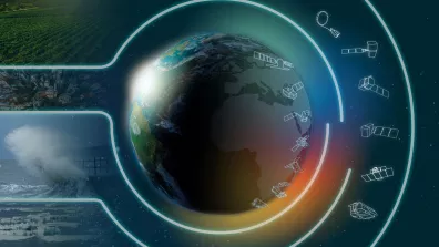
The ambition of Copernicus is to give Europe its own independent capability to observe and monitor Earth.
Key information
| Mission | Observation and monitoring of Earth, focusing particularly on the environment and security |
|---|---|
| Domain | Earth observation |
| Start date | Statement of intent in 1998, entry into operational service in 2014 |
| Partners | European Union, ESA, Eumetsat and member states |
| Where | Europe |
| Lifetime | Indefinite |
| Status | In operation |
Key figures
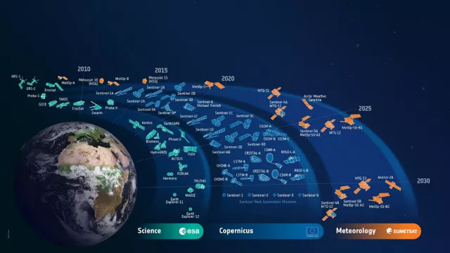
- 28 dedicated first-generation Sentinel satellites planned + 5 instruments on weather satellites
- 50+ satellites supplying and set to supply data for the Copernicus programme
- 8 Sentinel satellites already in Earth orbit
- 6 services fully operational
Key milestones
- > 2039: Launch of Sentinel-5C
- > 2032: Launches of Sentinel-4B, Sentinel-5B and Sentinel-6C
- > 2028: Launches of Copernicus Expansion CHIME, CIMR, CRISTAL, LSTM and ROSE-L satellites
- > 2028: Launch of CO2M-C
- > 2027: Launch of Sentinel-3D
- Q2 2027: Launch of CO2M-B
- Q1 2027: Launch of CO2M-A
- > 2026: Launch of Sentinel-2D
- Q3 2026: Launch of Sentinel-3C
- Q1 2026: Launch of Sentinel-4A
- 17 November 2025: Launch of Sentinel-6B
- 4 November 2025 : Launch of Sentinel-1D
- October 2025: Launch of Sentinel-5A
- December 2024: Launch of Sentinel-1C
- September 2024: Launch of Sentinel-2C
- 21 November 2020: Launch of Sentinel-6A by Falcon 9
- 25 April 2018: Launch of Sentinel-3B by Rockot
- 13 October 2017: Launch of Sentinel-5P by Rockot
- 6 March 2017: Launch of Sentinel-2B by Vega
- 25 April 2016: Launch of Sentinel-1B by Soyuz
- 16 February 2016: Launch of Sentinel-3A by Rockot
- 23 June 2015: Launch of Sentinel-2A by Vega
- 3 April 2014: Launch of Sentinel-1A by Soyuz
- 2014: Copernicus enters operational phase
- 2012: GMES renamed Copernicus
- 2011: EU Regulation on initial GMES operations
- 2001: EU and ESA launch GMES initiative (Global Monitoring for Environment and Security)
- 1998: Baveno Manifesto proposing an operational Earth-observation programme
Project in brief
Taking its cue from the way weather forecasting leverages space-based and in-situ measurements in optimal fashion, the European Union and the European Space Agency (ESA) launched the Global Monitoring for Environment and Security (GMES) initiative in 2001 to encourage development of operational services offering easy access to environmental information.
The aim is to streamline uptake of environment and security data derived from multiple sources in order to provide reliable information and services when needed. Renamed Copernicus in 2012, the programme pools all data from the Sentinel series of dedicated Earth-observation satellites, other contributing space missions and in-situ instruments to deliver a comprehensive and synoptic view of the planet.
For environmental monitoring, Copernicus will notably make it possible to track changes in land use and land cover, characterize land surface bio-geophysical variables, predict ocean state, support crisis management in natural or man-made disaster areas, monitor the chemical composition and quality of air, re-analyse essential climate variables (ECVs) and develop tools for establishing climate services.
For security aspects, it will aid enforcement of international treaties, support peacekeeping operations and assist European border and maritime surveillance.
To accomplish these missions, Copernicus relies on a dedicated constellation of Sentinel satellites providing radar and optical imagery, altimetry measurements and data on atmospheric composition, and on other contributing missions from national, European and international infrastructures. France is contributing to this team effort through satellites like SPOT, Jason and Pleiades. Alongside these space assets, member states supply in-situ data and a ground segment for data acquisition, processing and distribution. Copernicus is today fully operational, with eight Sentinel missions in orbit (one satellite lost) and six delegated thematic services. Access to Copernicus data is open and free of charge. Copernicus is Europe’s contribution to the Global Earth Observation System of Systems (GEOSS), an Earth-observation programme initiated by the EU, the United States, Japan and South Africa.
CNES’s role
CNES, via GEODES, which succeeds the PEPS Sentinel Product Exploitation Platform, is ESA’s national point of contact for all collaborative initiatives in France. It is also contributing to the Copernicus programme with expertise and technical support on satellite altimetry and optical remote-sensing missions.
Contacts
National Point of Contact for Copernicus collaborative projects
Bertrand Legras
E-mail: bertrand.legras at cnes.fr
Copernicus Programme Manager
Hervé Jeanjean
E-mail: herve.jeanjean at cnes.fr
Project news


