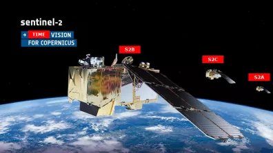
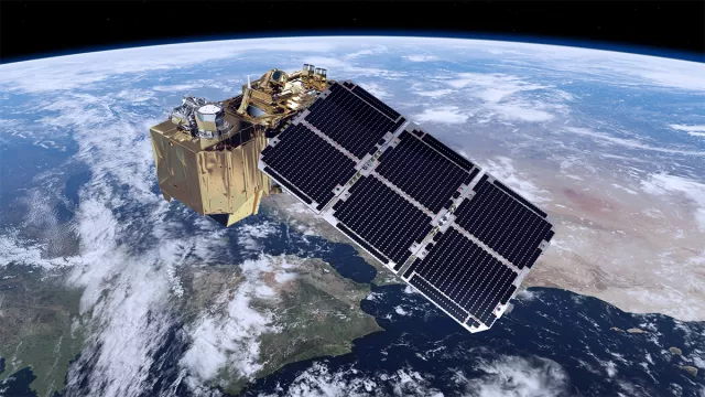
The optical component of Europe’s Copernicus programme, the Sentinel-2 mission beams back pictures of our planet in 13 spectral bands every five days. The twin Sentinel-2A and Sentinel-2B satellites—soon to be replaced by Sentinel-2C and Sentinel-2D—are surveying Earth’s land surfaces with frequent revisit rates, delivering high-resolution imagery for monitoring changes in plant cover, land occupancy and the impacts of global warming.
Key information
| Mission | Earth observation |
|---|---|
| Domain | Earth observation |
| Launch date | First satellite launched 23 June 2015 |
| Partners | European Union, ESA, consortium of 60 firms including Airbus Defence & Space |
| Where | 786-km polar orbit |
| Lifetime | 7 years, plus a further 7 years for second generation |
| Status | In operation |
Key figures
- 2 operational Sentinel-2 satellites
- 1,140 kg: mass of each satellite
- 10-to-60-m spatial resolution
- 5 days to image the entire globe
- 60 firms in the consortium that designed and built the two satellites
Key milestones
- 4 September 2024: Sentinel-2C launched to replace Sentinel-2A
- 7 March 2017: Sentinel-2B launched by Vega
- 23 June 2015: Sentinel-2A launched by Vega
- 2014: Copernicus enters operational phase
- 2012: GMES initiative renamed Copernicus
- 2001: EU and ESA launch Global Monitoring for Environment and Security initiative (GMES)
- 1998: Baveno Manifesto proposing an operational Earth-observation programme
Project in brief
The 1,140-kilogram European Sentinel-2A satellite lifted off from Kourou atop a Vega launcher on 23 June 2015. Its twin Sentinel-2B joined it in the same 786-kilometre orbit on 7 March 2017. Together, they deliver images with a ground swath of 290 kilometres and a resolution of 10 x 60 metres every five days, ranging from visible to mid-infrared wavelengths. On 4 September 2024, Sentinel-2C was launched to replace Sentinel-2A.
This imagery acquired every five days is like a time-lapse film of our changing planet, helping scientists to gain a deeper insight into how the climate machine works and the impacts of human activities. It serves a broad range of applications, monitoring crop and forest growth, land occupancy, farming practices and yields, as well as applications for which the satellites were not initially designed, like monitoring shorelines and coastal waters. Sentinel-2 also aids humanitarian organizations and governments to respond to emergencies such as landslides, volcano eruptions, floods and other natural disasters, through the International Charter Space and Major Disasters that calls on Earth-observation satellites to map events and support emergency response.
Drawing on the heritage of NASA’s Landsat and CNES’s SPOT programmes, the Sentinel-2 mission is part of the European Union’s Copernicus global environmental monitoring and security programme. The European Space Agency (ESA) is in charge of developing the satellites, their instruments, the ground segment and ensuring free, open distribution of imagery. The spacecraft were designed and built by a consortium of 60 firms headed by Airbus Defence & Space. Two new identical satellites—Sentinel-2C and 2D—are set to take over and ensure data continuity. And given the mission’s importance, the next generation of Sentinel-2 NG satellites is already in preparation.
CNES’s role
Under a cooperation agreement with ESA, CNES contributed its expertise from the project’s inception, providing support on assuring image performance, defining level 1 image-processing procedures (cloud masks, radiometric corrections, geometric corrections to reference images, etc.), developing the prototype for the data processing ground segment, an image quality centre and a level 2 image-processing demonstrator (fine cloud detection and atmospheric corrections).
After launch, CNES was actively involved with in-orbit commissioning of the two satellites, during which systems and algorithms are finely tuned to obtain the highest possible level of quality. Routine operations are today performed by an industry consortium, the OPTical Mission Performance Cluster (OPT-MPC), with CNES providing expertise and validating imagery. The agency is notably a member of ESA’s Quality Working Group (QWG), which formally defines recommended mission improvements. CNES strives to improve data products through regular instrument analyses and specific studies (error budgets, natural target calibration, etc.) and also contributes to exploitation of science data, notably with the CESBIO space biosphere research centre.
To foster and boost uptake of Sentinel-2 data, CNES makes them available for free via its online GEODES platform and delivers products corrected for atmospheric effects with MAJA.
Lastly, the Connect by CNES programme supports development of real-world solutions tailored to industry and institutional needs using Sentinel-2 imagery and leveraging synergies with many other missions.
Contacts
Project Manager
Damien Rodat
E-mail: damien.rodat at cnes.fr
Continental Biosphere subject matter expert
Philippe Maisongrande
E-mail: philippe.maisongrande at cnes.fr
Project news


