Authors
This blog article was written by Olivier Hagolle and Damien Rodat, with contributions from Aimé Meygret, Céline Tison, Simon Baillarin and Philippe Maisongrande.
The first Sentinel-2 satellite was launched on the 23rd of June 2015, already 10 years ago ! Thanks to its resolution (10 to 20 m depending on the spectral band), its revisit (5 days), its 13 spectral bands, and its free and open global observations, the Sentinel-2 mission quickly became one of the most used and useful space missions in the world (400 000 users so far from Copernicus servers, and much more elsewhere, including our own server Geodes ! ). The mission was funded by the EU's Copernicus budget, and by ESA and its member states' contributions. The high-performance satellite and high-quality instrument were produced by Airbus Defence and Space. CNES made a major contribution to the definition of the mission and its fine products. This tenth birthday is therefore an opportunity to recall our contributions to this wonderful mission.
Mission proposal
When Sentinel-2 was decided, CNES had already acquired considerable experience in optical missions, with the SPOT satellites (5 satellites launched between 1986 and 2002) and the preparation of Pleiades. The SPOT satellites were a great success, but their imaging capacity was not sufficient to observe the whole world frequently. SPOT satellites could choose to observe to the right or left of orbit, by moving a mirror. This was convenient for a user interested in a small area, but not suited to the need for frequent coverage of a whole territory. The application demonstrations we carried out on a local scale were generally not transposable to an entire country or continent. This was the task of the VEGETATION instruments on SPOT4 and SPOT5, but with a resolution of one kilometer only.
To compensate for this shortcoming, the CESBIO laboratory proposed missions enabling multi-temporal, high revisit monitoring with a resolution of the order of 10 meters. In 1998, Rhea (Dedieu et al 2003) was proposed as a small demonstration mission, which later became the VENµS satellite, with 100 sites observed every 2 days at 5m resolution. In 2003, CNES studied the “GMES continental” mission in phase-0 (pre-project), which proposed global coverage every 3 days (Beghin, Dedieu, Hagolle). The Sentinel-2 mission, finally decided by ESA and the European Union, is very similar to “GMES continental”, which phase-0 report was shared with ESA.
VENµS was aimed as a demonstrator for Sentinel-2, but the setbacks to the project delayed the launch after Sentinel-2, in 2017, reducing its role in the in-flight preparation of Sentinel-2. However, all the work carried out on the VENµS project had nevertheless prepared the teams well for the Sentinel-2 mission. For example, the GRI (Global Reference Image) concept implemented on Sentinel-2 to refine the geometric model of on-the-fly images (see below) is an extrapolation to the globe of the processing specified for VENµS.
Preparatory data acquisition
To prepare a new mission properly, it is very useful to have data that look alike future data. For Sentinel-2 and VENµS, we were lucky enough to be able to rely on the Formosat-2 satellite, built by Airbus Defense and Space for Taiwan. As early as 2005, we obtained several Formosat-2 time series, acquired at constant observation angles. These series enabled us to understand the challenges of future VENµS and Sentinel-2 data (Hagolle et al 2008, 2010, 2015). To expand the areas covered and reach more users in Europe and around the world, we, with the blessing of CNES, diverted the SPOT4 and SPOT5 satellites at the end of their life in orbit for the "Take5" experiments (Hagolle et al 2015, Inglada et al, 2015). The satellites were placed in a 5-day phased orbit, making it possible to reproduce the revisit soon to be offered by Sentinel-2. Several dozen laboratories were thus able to learn how to use this type of data and start developing their processing.
To understand the problems brought about by the wide spatial coverage, we also processed Landsat data (this was not easy in Europe in 2010), and it was on this occasion that we realized that it was practical to slice the data into 100*100 km² tiles, with some overlap to avoid data quality being degraded at the image edge (Hagolle, 2015, Mira 2016). This tiling system is still in use for Sentinel-2 and has been adopted by Landsat over the USA.
-

Image of Landes forest in France taken by Formosat-2 20 years ago. On these images vegetation appears in red. A thick haze is present. -

Same region observed one day later, the haze has disappeared. This pair of images prompted us to work on multi-temporal methods for determining the optical properties of the atmosphere.
-

Two Formosat-2 images acquired 9 years before the launch of Sentinel-2, acquired 12 days apart, in the Marrakech region of Morocco. -

Comparison of the two images reveals the presence of clouds and their shadows. This pair of images prompted us to work on multi-temporal detection of clouds and their shadows.

Research support
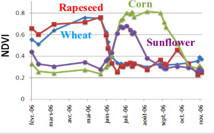
In addition to these preliminary data (Formosat-2, LANDSAT, Take5), CNES has also provided financial support for the work of users, and in particular researchers, through the TOSCA budget. The illustrations below show the evolution over time of the research efforts leading to the land cover product currently delivered by the THEIA land data center.

Taking part in the development of the Sentinel-2 system
During the development phase of the Sentinel-2 mission, and as part of a collaboration agreement between ESA and CNES, an Image Quality team (6 CNES engineers and as many technical assistants) was set up at CNES in 2008. Two CNES engineers, Aimé Meygret then Thierry Tremas, and Simon Baillarin, were associated with the project teams at ESA and technically led the CNES team. An end-to-end image simulator (SPS), an Image Quality Expertise Center (TEC-S2) and a prototype of the level 1 processing chain (GPP) were developed in Toulouse, with CNES technical supervision of an industrial team.
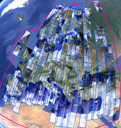
CNES defined Sentinel-2 products up to level 1C and recommended the content of the level 2 products available today, providing reflectances (some asked for luminance) cut into 110 km tiles, with a 10 km overlap. It was also CNES who suggested using the MGRS tile grid to ensure the same data sampling for each use, and to facilitate the use of image time series, as seen on the Strait of Gibraltar sequence (below). CNES provided the specifications for the processing chains up to level 1C (radiometric corrections, calibration, geometric corrections), showed that it was possible to refine the data overlay in real time, and defined all the validation methods for radiometric calibration.
Taking part in commissionning phases and image quality assessment
To ensure that ESA benefits from its experience with optical observation satellites, CNES has been involved in in-flight acceptance work since the launch of Sentinel-2A, and in the longer term in ESA's S2 Quality Working Group, where Damien Rodat currently represents CNES' image quality teams. For the first two satellites, CNES was responsible for all aspects of image quality. It then transferred its skills to the OPT-MPC (OPTical Mission Performance Cluster), an ESA-funded consortium responsible for calibration and validation.
CNES then focused on its role as expert (providing technical support to ESA in setting up geometric refinement, Moon calibration, etc.) and assessing image quality. Even today, the team of measurement physicists ensures constant radiometric follow-up of the mission's products, using 6 calibration methods on natural targets: deserts, domes (Antarctica), instrumented sites (RadCalNet), Rayleigh scattering over the oceans, deep convective clouds and, more recently with Sentinel-2 C, the Moon. These methods have revealed, for example, that the sensitivity of the two satellites Sentinel-2A and 2B differed by around 1%. This small difference has since been corrected. Similarly, during the flight acceptance of Sentinel-2C, CNES helped ESA to correct a radiometric bias so that the radiometry of all three Sentinel-2s was consistent to within 1%.

CNES teams were also involved in the in-flight acceptance tests and in validating the geometry of Sentinel-2 images. As soon as Sentinel-2 was declared operational, CNES, in collaboration with IGN, introduced the Global Reference Image (GRI) concept. This has made it possible to produce the first geometric refinements offering pixel-perfect localization of Sentinel-2 images, a process eagerly awaited by users and finally put into operation by ESA in early 2021.
The image quality service continues to ensure geometric validation through regular analyses, warning ESA and OPT-MPC of any deviation from the parameters. In addition, this fine expertise in the instrument is shared with scientists to develop innovative applications such as the study of swell and marine currents, made possible by the exploitation of particular features of the instrument not accessible to the general public (i.e. the presence of pixels acquired almost simultaneously by two detectors). The radiometric and geometric validation exercises carried out at CNES involve the processing of over 1,000 Sentinel-2 products per year, and simultaneously enable us to upgrade our tools and improve data quality to level 1.
Advanced products (surface reflectance)
In the framework of THEIA Land data center, CNES provides users with ARD products (Analysis Ready Data) of better quality than those of ESA. In particular, the whole Europe is processed with the MAJA processor developed by CS for CNES, and designed at CESBIO, which provides instantaneous surface reflectances with a good cloud mask. The WASP processor, is also used to provide monthly syntheses of cloud-free observations. The WASP chain was also designed at CESBIO.
Data distribution and management of the French user community
Since the launch of Sentinel-2, CNES has been an important relay for French Sentinel-2 users (and also worldwide users). Sentinel-2 data acquired worldwide are stored at the CNES computing center, and can be accessed via the GEODES portal. As part of the THEIA thematic cluster for land surfaces, within the DataTerra research infrastructure, scientists are encouraged to propose new applications for Copernicus data, which can be put into production at CNES or THEIA's space data centers.
The knowledge of the Sentinel-2 system and of user needs led us to feel that a petition to keep Sentinel-2A operational for longer after the launch of Sentinel-2C was relevant. It was signed by over 2,000 people, and prompted the EU and ESA to extend the satellite's operation by a further year, until at least May 2026!
Finally, through the intermediary of Olivier Hagolle, CNES is participating in the Mission Advisory Group for the definition of the Sentinel-2 NG mission, which could be launched in 2034, and should enable an improvement in resolution and the addition of spectral bands. CNES and the scientific community are pushing hard for increased revisit: Sentinel-2 users, please send us your observations of the improvement brought about by using 3 satellites instead of two!
References
- G. Dedieu, F. Cabot, A. Chehbouni, B. Duchemin, P. Maisongrande et al., RHEA: a micro-satellite mission for the study and modeling of land surfaces through assimilation techniques. EGS- AGU-EUG Joint Assembly, 2003.
- Hagolle, O., Dedieu, G., Mougenot, B., Debaecker, V., Duchemin, B., & Meygret, A. (2008). Correction of aerosol effects on multi-temporal images acquired with constant viewing angles: Application to Formosat-2 images. Remote sensing of environment, 112(4), 1689-1701.
- Hagolle, O., Huc, M., Pascual, D. V., & Dedieu, G. (2010). A multi-temporal method for cloud detection, applied to FORMOSAT-2, VENµS, LANDSAT and SENTINEL-2 images. Remote Sensing of Environment, 114(8), 1747-1755.
- Hagolle, O., Huc, M., Pascual, D. V., & Dedieu, G. (2015). A multi-temporal and multi-spectral method to estimate aerosol optical thickness over land, for the atmospheric correction of FormoSat-2, LandSat, VENμS and Sentinel-2 images. Remote Sensing, 7(3), 2668-2691.
- Inglada, J.; Arias, M.; Tardy, B.; Hagolle, O.; Valero, S.; Morin, D.; Dedieu, G.; Sepulcre, G.; Bontemps, S.; Defourny, P.; et al. Assessment of an Operational System for Crop Type Map Production Using High Temporal and Spatial Resolution Satellite Optical Imagery. Remote Sens. 2015,
- Hagolle, O., Sylvander, S., Huc, M., Claverie, M., Clesse, D., Dechoz, C., ... & Poulain, V. (2015). SPOT-4 (Take 5): Simulation of Sentinel-2 time series on 45 large sites. Remote sensing, 7(9), 12242-12264.
- Maria Mira, Albert Olioso, Belén Gallego-Elvira, Dominique Courault, Sébastien Garrigues, Olivier Marloie, Olivier Hagolle, Pierre Guillevic, Gilles Boulet, Uncertainty assessment of surface net radiation derived from Landsat images, Remote Sensing of Environment,Volume 175, 2016,
- Lonjou, V., Lachérade, S., Fougnie, B., Gamet, P., Marcq, S., Raynaud, J. L., & Tremas, T. (2015). Sentinel-2/MSI absolute calibration: first results. Sensors, Systems, and Next-Generation Satellites XIX, 9639, 34-44.
- M. Drusch, U. del Bello, S. Carlier, O. Colin, V. Fernandez, F. Gascon, B. Hoersch, C. Isola, P. Laberinti, P. Matimort, A. Meygret, F. Spoto, O. SY, F. Marchese, P. Bargellini, Sentinel-2: ESA's Optical High-Resolution Mission for GMES Operational Services, Remote Sensing of Environment, Volume 120, 15 May 2012, Pages 25-36. https://doi.org/10.1016/j.rse.2011.11.026
- Baillarin S. J ; Meygret A., Dechoz C., Petrucci B., Lacherade S., Tremas T., Isola C., Martimort P., Spoto F., Sentinel-2 Level 1 Products and Image Processing Performances, July 2012, The International Archives of the Photogrammetry Remote Sensing and Spatial Information, DOI:10.5194/isprsarchives-XXXIX-B1-197-2012 Sciences XXXIX-B1:197-202
- Gascon, F.; Bouzinac, C.; Thépaut, O.; Jung, M.; Francesconi, B.; Louis, J.; Lonjou, V.; Lafrance, B.; Massera, S.; Gaudel-Vacaresse, A.; et al. Copernicus Sentinel-2A Calibration and Products Validation Status. Remote Sens. 2017, 9, 584. https://doi.org/10.3390/rs9060584