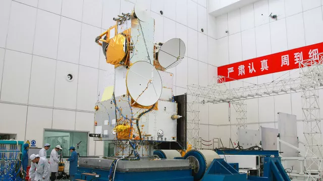
Launched in 2011, HY-2A is an oceanography satellite belonging to China’s HaiYang programme with CNES’s DORIS instrument on board, enabling its orbit to be determined with centimetre accuracy.
It was followed by HY-2B (without DORIS), HY-2C and HY-2D (with DORIS).
Key information on HY-2A
| Mission | Study the ocean |
|---|---|
| Domain | Earth observation |
| Launch date | 15 August 2011 |
| Partners | NSOAS (National Satellite Ocean Application Service), CNSA |
| Where | Polar 971-km orbit for oceanography mission Polar 973-km orbit for geodesy mission |
| Lifetime | Initially 3 years |
| Status | Completed |
Key figures
- 1,500 kg: satellite mass
- 7 instruments
- 18 operational satellites planned in the HaiYang programme: HY-2A (mission over), HY-2B, HY-2C, HY-2D
- 1 DORIS receiver on satellites (except HY-2B)
Key milestones
- 19 May 2021: Launch of HY-2D
- 21 September 2020: Launch of HY-2C
- 25 October 2018: Launch of HY-2B
- 15 August 2011: Launch of HY-2A by Long March 4B
- 2007: CNSA gives go-ahead to develop mission
Project in brief
Haiyang means ‘ocean’ in Chinese, thus the ‘HY’ in HY-2A, a Chinese satellite dedicated to studying sea-surface height, temperature and wind speed. Launched on 15 August 2011, HY-2A complements the HY-1A and HY-1B satellites that acquired ocean colour measurements for ocean biology studies.
To determine sea-surface height, HY-2A uses a radar altimeter that measures the satellite’s distance or ‘range’ to the ocean surface and a DORIS instrument developed and supplied by CNES. Operating in combination with a laser retroreflector and GPS receiver, DORIS enables the satellite’s orbital position to be determined with centimetre accuracy. CNES also provides support for orbit determination operations.
CNES’s role
CNES developed the DORIS instrument flying on the HY-2A satellite and provided operational support to teams determining its orbit.
For subsequent missions—HY-2C and 2D currently in orbit, and HY-2E and 2F in development—NSOAS is procuring DORIS instruments directly from the manufacturer Thales-DMS, to which CNES is providing support for system aspects.
Concerning the ground segment, since HY-2A in 2011 CNES has processed all DORIS measurements from the satellites and provided NSOAS with precise orbit data on a daily basis. In exchange, CNES has access to Chinese level 2 geophysical products, which it feeds into the Sea Level TAC and Wave TAC for the Copernicus Marine Environment Monitoring Service (CMEMS).
Contacts
HY-2 Project Leader operations
Matthias Raynal
E-mail: Matthias.raynal at cnes.fr
DORIS Project Leader
Olivier Dumond
E-mail: Olivier.dumond at cnes.fr
Oceans subject matter expert
Yannice Faugère
E-mail: yannice.faugere at cnes.fr


