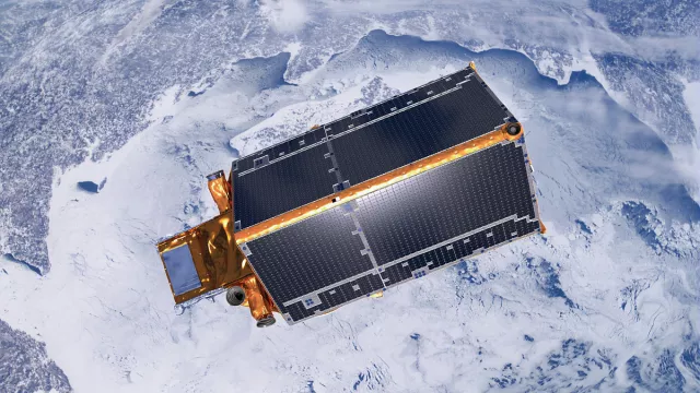
Launched in 2010, CryoSat-2 is Europe’s first satellite dedicated to observing polar ice. Capable of measuring ice thickness with centimetre accuracy, it is tracking ice volume and extent and supplying data to validate predictions of impending ice melt as a result of global warming.
Key information
| Mission | Study polar ice |
|---|---|
| Domain | Earth observation |
| Launch date | 8 April 2010 |
| Partners | ESA |
| Where | Polar orbit (inclination 92°, altitude 717 km) |
| Lifetime | Mission in operation with new products still being generated from CryoSat-2 data (e.g. sea level anomaly (SLA) product) |
| Status | In operation |
Key figures
- 720 kg satellite mass
- 6 instruments and sensors
- 2 to 5 cm measurement accuracy for ice thickness in Arctic Ocean
- 2 mm measurement accuracy for ice thickness in Antarctic Ocean
Key milestones
- 23 August 2023: UK National Oceanography Centre (NOC), in partnership with ESA, publishes CryoSat-2 dataset accessible here
- 12 July 2022: CryoSat-2’s orbit is aligned with that of ICESat-2 over the Antarctic. The two orbits are quasi-synchronous
- 16-31 July 2020: ESA raises CryoSat-2’s orbit to align it periodically with that of NASA’s ICESat-2 satellite
- 2014: ESA adds and implements processing chain for ocean research
- 8 April 2010: CryoSat-2 launched by Dnepr vehicle
- 5-6 December 2005: ESA gives go-ahead to build and launch CryoSat-2
- 8 October 2005: CryoSat-1 lost on launch
Project in brief
The launch of CryoSat-1 in 2005 may have ended in failure, but the mission rose from the ashes and in 2010 CryoSat-2 was sent into a 717-km polar orbit from the Baikonur Cosmodrome in Kazakhstan atop a Russian-Ukrainian Dnepr launcher. For the first time ever, it would measure the thickness of sea and land ice—the ice caps of the Antarctic and Greenland—from space with centimetre accuracy.
CryoSat-2 is carrying an innovative radar altimeter instrument called SIRAL. Built in France by Thales Alenia Space, SIRAL continuously measures the distance or range from the satellite to the ice surface and employs an interferometric mode to map the rugged relief of the polar ice caps.
But to determine ice thickness, we need to establish another parameter: the satellite’s orbital position. This is measured—also with centimetre accuracy—by the DORIS system. Developed by CNES and the French mapping and survey agency IGN, DORIS consists of an instrument on CryoSat-2 that communicates with 60 ground stations transmitting signals to the satellite.
Without DORIS, CryoSat-2 would have been unable to achieve its objectives and answer many of the questions raised by global warming. For example, is polar ice melt gaining pace? Is ice melting faster in Antarctica than in the Arctic? Does it reform completely every year? And to what extent is polar ice melt contributing to rising sea level?
CNES’s role
The DORIS system on CryoSat-2 was developed by CNES and IGN.
CNES is also involved in other ways in the CryoSat-2 mission, providing:
- Through-life support for the spaceborne DORIS instrument and handling in-orbit anomalies
- The DORIS ground infrastructure (beacons)
- Real-time and off-line orbit determination thanks to the spaceborne DORIS instrument and ground processing at the SSALTO multi-mission centre
- Long-term archiving via a service contract using the generic STAF data transfer and archiving department at its Data Processing Centre (DPC)
- CryoSat-2 data through the SSALTO DUACS system
Contacts
Project Leader
Thierry Guinle
E-mail: thierry.guinle at cnes.fr
Coasts, Littoral and Marine Cryosphere subject matter expert
Aurélien Carbonnière
E-mail: aurelien.carbonniere at cnes.fr


