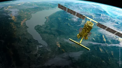
The French-U.S. SWOT satellite, launched on 16 December 2022, has been delivering surface water height data of exceptional quality from all over the globe for more than 18 months now. A key milestone was reached recently with the completion of the satellite’s validation phase, confirmed at a meeting between CNES and NASA teams and the SWOT Science Team, paving the way to distribution of validated science data products
A joint French-U.S. mission with contributions from the Canadian Space Agency (CSA) and the UK Space Agency (UKSA), SWOT has the capability to measure water heights across most of the globe, providing a high-resolution map of our planet’s water resources for the first time ever. The satellite’s wide-swath interferometric radar sensor provides a detailed picture of sea surface height every 250 metres and of waterways wider than 100 metres and surface water bodies of one hectare or more, with a revisit frequency of 21 days. SWOT data draw on a heritage of 30 years of continuous progress in the field of satellite altimetry and are the culmination of several decades of French-U.S. space cooperation.
Thanks to its Ka-band Radar Interferometer(KaRIn), SWOT is delivering the first ever global-scale measurements of water height and extent for millions of lakes, wetlands and reservoirs. For example, the Lac de Montbel, a reservoir filled in 1985in the South of France, is one of many reservoirs in France. Data on this reservoir acquired by SWOT are a perfect illustration of the satellite’s ability to provide regular updates on water levels. Such global monitoring of surface waters is yielding information on freshwater stock status, including in remote regions where in-situ measurements are lacking, like wetlands. This broad picture is giving scientists new insights into the water cycle and improving hydrological—notably for flood forecasting—and climate prediction models. It also provides crucial information to authorities for a range of applications including management of potable water resources, production of hydroelectricity and crop irrigation.
In the field of oceanography, SWOT is able to detect eddies ten times smaller than anything seen by previous satellite altimetry missions. In the Gulf Stream off the coast of the United States, it reveals two eddies—in red at the top and blue at the bottom—each spanning 30 to 50 kilometres (see photo attached). Between them, we see several eddies no larger than a few kilometres across: such data acquired in a single satellite pass are unprecedented. This new vision of the oceans and coastal regions should help us to delve deeper into the role of small eddies in shaping climate, as well as their relationship with major ocean currents and zones rich in biodiversity. It brings a new dimension to ocean research, enabling closer interactions between physical oceanography and biological productivity and paving the way for better management of the marine environment (e.g. through the identification and creation of Marine Protected Areas).
To make SWOT data available to a broad scientific and user community, products are distributed via NASA Earthdata Search in the United States and Data Terra in France. The French Hydroweb.next portal operated by CNES provides access to SWOT hydrology data combined with other satellite and field data, numerical models, drone data and more, while the AVISO+ portal offers access to sea-surface height data acquired by altimetry satellites. Based in Toulouse and run by CNES, this website hosts a 20-year record of altimetry data. In the U.S., NASA’s Physical Oceanography Distributed Active Archive Center (PO.DAAC) hosts SWOT’s hydrology and oceanography science data products, as well as oceanography data products from other satellites such as Sentinel-6 Michael Freilich.
Space and Earth’s oceans are two vast and fragile expanses whose destinies are closely tied. For the UN Ocean Conference (UNOC) to be held in Nice in June 2025, CNES is setting in train an initiative called the Space4Ocean Alliance[1] aimed at federating the efforts of space agencies, government agencies and scientific communities to get space technologies working more for oceans across the board.
[1] The Space4Ocean Alliance (S4O) seeks to help preserve and protect the world’s oceans, leveraging Earth-observation satellite data and products to deliver operational sustainable management solutions for emerging and island nations. This alliance would bring together space agencies, research bodies, multilateral organizations, NGOs and UN member states with a view to federating the needs and priorities of target countries and strengthening operational ocean monitoring capabilities.
SWOT: the culmination of a 30-year collaboration between France and the U.S.A
In the 1980s, scientists at CNES and NASA looking for a way to analyse ocean perturbations came up with an altimetry concept capable of delivering new insights into oceans and their impact on climate. This led to the development of the TOPEX/Poseidon programme, followed by the Jason series of satellites and Sentinel-6 Michael Freilich, which all added to the record of ocean data. Subsequent research and development efforts have improved ocean altimetry performance while enabling measurement of land surface waters like rivers and lakes.
Led by the French space agency CNES (Centre National d’Études Spatiales) and NASA (National Aeronautics and Space Administration), the SWOT mission is able to measure and survey water on over 90% of Earth’s surface, providing a high-resolution map of our planet’s water resources for the first time ever. The satellite’s measurements of surface water and ocean heights will help to further in-depth studies of water resource management and revolutionize our understanding of the global water cycle and how it is being affected by climate change.
SWOT was jointly developed by NASA and CNES, with contributions from the Canadian Space Agency (CSA) and the UK Space Agency (UKSA). The Jet Propulsion Laboratory (JPL) leads the U.S. component of the project on behalf of NASA. For the flight system payload, NASA provided the Ka-band Radar Interferometer (KaRIn) instrument (for which CSA supplied the high-power amplifier or extended interaction klystron (EIK)), a GPS science receiver, a laser retroreflector, a two-beam microwave radiometer and built the payload module delivered to CNES. NASA also provided the launch vehicle. CNES supplied the Doppler Orbitography and Radiopositioning Integrated by Satellite (DORIS) system, the dual-frequency Poseidon altimeter (developed by Thales Alenia Space), the KaRIn radio-frequency subsystem (developed by Thales Alenia Space with support from UKSA) and the spacecraft bus (with Thales Alenia Space as prime contractor) and developed the satellite’s ground control segment. CNES is also responsible for operations and for processing data received daily from the KaRIn instrument, while NASA is also responsible for reprocessing data from the KaRIn instrument.
