Travellers and goods alike were long reliant on waterways rather than roads to get from one place to another. While certain waterways or canals in Europe today are only used for leisure purposes, goods are still being conveyed on many of them. Elsewhere around the world, waterways are still widely used as a means of getting around. But, depending on boat sizes and cargoes, some are only navigable if the water is deep enough. As a result, a drop in level can render major waterways unusable for long periods, like in 2022 on the Rhine and on the Panama Canal during the dry season. River levels are not systematically monitored in-situ everywhere and in certain cases data are only collected at measuring stations.
Now complementing field data although not dispensing with them altogether, the French-U.S. SWOT mission led by CNES and NASA is taking hydrology into the realm of satellite altimetry. The mission’s main instrument, the KaRIn radar interferometer, acquires precise data on variations in water height for rivers as narrow as 100 metres across, and for lakes and wetlands with a surface area of more than a hectare.
While SWOT data do not measure waterway depth directly, they should tell us if they are navigable or not by comparing them with usual depths to provide operators with navigation bulletins. In Europe, the Rhine is one of the busiest navigable waterways for transporting goods. The river is closely monitored and controlled, enabling SWOT data to be validated and confirming that the mission is accurately estimating water levels on both sides of the river’s dams.
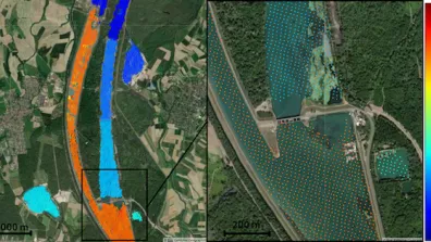
The images below, acquired by the satellite as it passed over the Rhine south of Strasbourg, are a perfect illustration of the hydrology information the mission is capable of delivering. They show the water height on both sides of a hydroelectric dam, revealing a sharp variation of seven metres or so, changing from orange to blue.
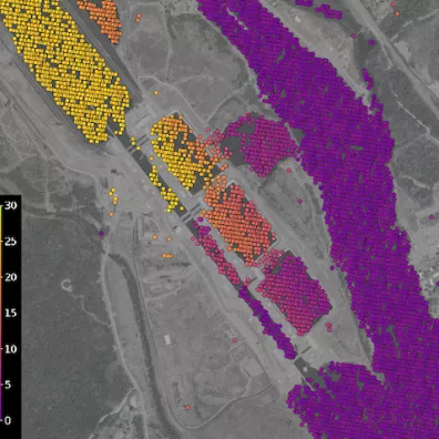
The Panama Canal is another example of the precision of SWOT data. Locks at either end of the canal take ships as far as Lake Gatún, a freshwater artificial lake lying 26 metres above sea level. On average, 200,000 m3 of freshwater is needed for a single ship to pass through a lock, the equivalent of 80 Olympic-size swimming pools. Unfortunately, the region is subject to quite severe droughts and the level of the lake may drop significantly, making the canal unusable or limiting the number of ships. As the canal’s level is naturally measured along its entire length, observing it with SWOT has confirmed the satellite’s potential and accuracy for such complex installations, as shown in the image below.
Oceanography data from the SWOT mission can be accessed via the AVISO platform and hydrology data at hydroweb.next.
