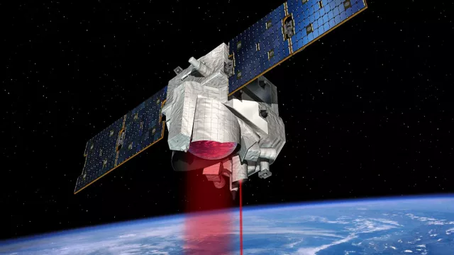
In 2029, the French-German MERLIN satellite (Methane Remote Sensing Lidar Mission) will go into Earth orbit to measure concentrations of atmospheric methane with unprecedented precision and thus better understand the sources of this greenhouse gas playing a key role in global warming.
Key information
| Mission | Measure methane concentrations in Earth’s atmosphere and identify emission sources |
|---|---|
| Domain | Earth observation |
| Launch date | 2029 |
| Partners | DLR, Airbus DS GmbH |
| Where | Sun-synchronous polar orbit, at an altitude of around 500 km |
| Lifetime | At least three years |
| Status | In development |
Key figures
- 430 kg: satellite mass
- 1 instrument: IPDA lidar
- 50-km horizontal resolution
- 690-mm-diameter lidar mirror
Key milestones
- 2029: Scheduled launch of MERLIN
- April 2017: Critical Design Review
- February 2017: DLR tasks Airbus DS GmbH to build satellite
- 2012: Phase A of development completed
- February 2010: CNES and DLR approve mission
Project in brief
Precisely measuring concentrations of atmospheric methane to quantify and locate emission sources and their variation is key to achieving a closer understanding of Earth’s climate mechanisms. To give an idea of its role, a tonne of methane has 25 times more impact on global warming than a tonne of carbon dioxide over a timescale of a century.
That is why CNES and the German space agency DLR decided to jointly develop the MERLIN satellite (Methane Remote Sensing Lidar Mission), scheduled to launch in 2029.
Its mission will be to measure methane concentrations in Earth’s atmosphere with unprecedented precision, to characterize natural (flood zones, notably due to thawing of permafrost in the Arctic) and anthropogenic (transport and transformation of coal and natural gas, ruminant livestock, etc.) sources of the gas.
To accomplish this mission, MERLIN will be relying on its methane Integrated Path Differential Absorption (IPDA) lidar, which will fire laser beams towards Earth’s surface and then analyse the signal bounced back to deduce the amount of methane in the sounded atmospheric column.
DLR is supplying the IPDA lidar, while CNES will supply a new version of its Myriade-Evolutions spacecraft bus. CNES is system and satellite prime contractor. It will also be in charge of the satellite control centre and data distribution during the operational phase of the mission.
CNES’s role
CNES and DLR are jointly developing the MERLIN satellite.
Contacts
Project Leader
Mathieu ALBINET
E-mail: mathieu.albinet at cnes.fr
Performance Manager
Christel Guy
E-mail: christel.guy at cnes.fr
Atmospheric Composition & Carbon Cycle subject matter expert
Carole Deniel
E-mail: carole.deniel at cnes.fr


