Earth’s continents are dotted with both natural and man-made water bodies. The latter serve as reservoirs and fulfil several functions, maintaining the level of rivers and streams in drought conditions and taking up overflows when they rise. They are also a potential reserve for irrigation and for generating electricity with hydroelectric turbines when the water level is high enough. They are also popular destinations for nautical leisure activities, providing a place for urban populations to cool off in the heat of summer.
In France, reservoirs are closely monitored by water boards working in tandem with government, using in-situ measurements from ground stations. Water resource management and planning is based on the principle of lowering the level before rainfalls come in order to be ready to respond in the event of rivers overtopping, and retaining as much water as possible before the dry season to be able to sustain irrigation and maintain river flow.
Thanks to its KaRIn radar interferometer, the SWOT mission is delivering the first ever global-scale measurements of water height and extent for millions of lakes, wetlands and reservoirs. These data are yielding information on freshwater stock status, including in remote regions where in-situ measurements are lacking.
This broad perspective is helping scientists to gain new insights into the water cycle and improving hydrological—notably for flood forecasting—and climate prediction models. It is also giving government vital information for numerous applications like fresh water resource management, hydroelectricity generation and crop irrigation.

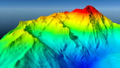
The Lac de Montbel, a reservoir filled in 1985 that straddles the border between the departments of Ariège and Aude, is one of many reservoirs in France. Data acquired by the SWOT mission for this reservoir are a perfect illustration of its ability to provide regular updates on water levels.
The image shown above combines data acquired on 5 November 2023 and 27 February, 20 April and 11 June 2024. We can see that the reservoir level rose over the period covered, rendered by the different colours: blue hues when the level was at its lowest, to orange when highest coming out of winter. These data, confirmed by in-situ measurements, are the result of the use of this reserve of water to irrigate crops in the Lauragais region and on the Ariège plain in response to the particularly long drought episode that started in 2022.
Oceanography data from the SWOT mission can be accessed via the AVISO platform and hydrology data at hydroweb.next.
To learn more, see our dedicated SWOT mission web page.