“I proposed this mission in 2005 with the aim of quantifying plant biomass, in other words, the amount of organic plant matter in forests,” explains Thuy Le Toan, the mission’s co-principal investigator. “At the time, nobody believed it possible to build a satellite with a radar capable of measuring forest biomass, especially in tropical rainforests, where the stakes are high and the gaps in data most evident.”
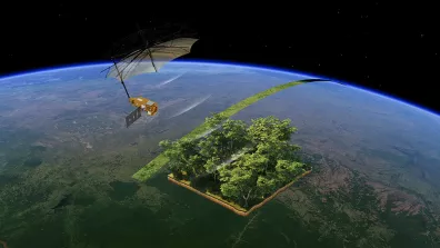
20 years on, Thuy Le Toan’s satisfaction is understandable as Biomass gets ready to launch from the Guiana Space Centre. The European Space Agency (ESA) satellite is carrying a radar that operates in P band, at a low frequency (435 MHz) and long wavelength (70 cm)—a world first. At this wavelength, the radar wave is able to penetrate the forest canopy down to 40 metres and see through leaves to measure the biomass stored in branches and trunks.
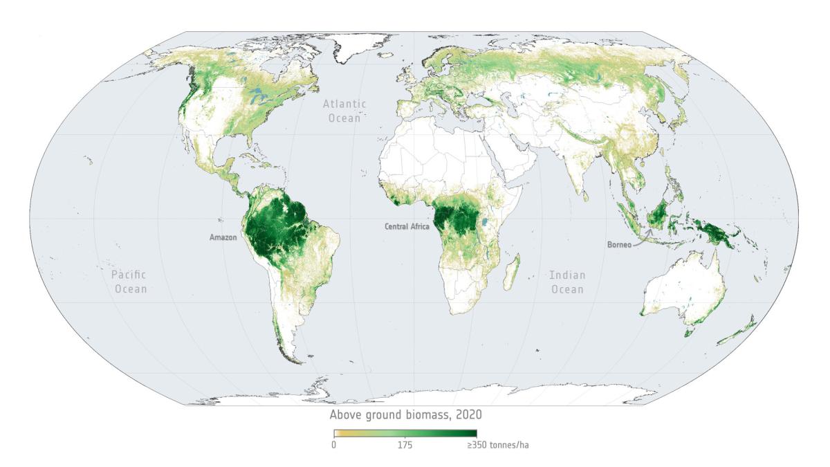
Scientists are eagerly awaiting the satellite’s data to gain new insights into the key role that forests play in the carbon cycle and in regulating Earth’s climate. “Biomass will give us a clearer picture of the quantity and distribution of forest biomass,” notes Thuy Le Toan enthusiastically. “In other words, the amount of carbon stored in our forests and how it varies in response to human activities and climate.”
Putting methods to the test
Biomass is an inherently scientific satellite. “From the word go, the mission was shaped by scientists to answer scientific questions,” says Thierry Koleck, Biomass project manager at CNES. “And CNES made a clear choice to work on the mission alongside French research scientists.”
In 2009, with the mission still on the drawing board, ESA and CNES supplied funding for an exploratory study named TropiSAR. This study involved acquiring measurements with a P-band radar from a French science aircraft flying over French Guiana’s forests. “We set out to prove that it was possible to deduce biomass from radar data,” recalls Thuy Le Toan. “We even degraded the radar signal to simulate disturbances a signal would be subjected to during its round-trip to the satellite and back to Earth.”
The study was a success. The results of the airborne survey campaign, added to those already obtained in Gabon in 2015 and 2016, showed that it was possible to map forest structure in 3D and thus deduce biomass and tree height.
This close collaboration between space agencies and scientists has continued to drive, shape and structure the mission, for example through the Mission Advisory Group (MAG) of 12 experts in the fields of ecology and radar remote sensing. The MAG notably served as a relay between the European research teams (see box) working on Biomass and the space agencies. Their work helped refine the mission’s specifications.
Laurent Ferro-Famil, a lecturer and research scientist at the ISAE-SUPAERO aerospace engineering school specialising in radar signal processing, heads up the Biomass research team at the CESBIO biosphere research centre: “We’ve notably designed and prototyped specific data processing methodologies,” he says. “And we’ve put together instruction sheets for future users.”
A European scientific community
The CESBIO biosphere research centre where Thuy Le Toan works, and where the mission originated, is a joint research unit of CNES, CNRS, IRD, INRAE and the University of Toulouse. But in all, ten French research laboratories are contributing to Biomass, alongside research centres in Germany, Italy, the Netherlands, Sweden and the United States.
Another example is the experiment conducted between 2011 and 2015 in forests in French Guiana and Ghana to study the reflectivity of these ecosystems with a view to optimizing the mission.
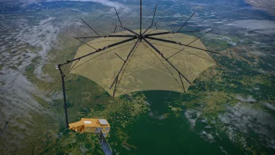
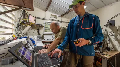
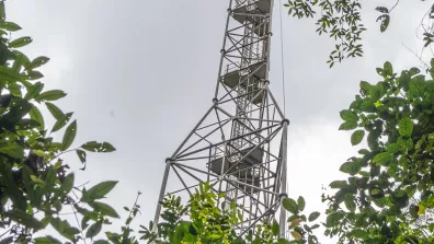
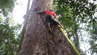
“We rigged up instruments deep in the forest, at the top of a 50-metre high tower,” recounts Thuy Le Toan. “They measured the P-band radar signal bouncing back from the forest almost continuously. We were thus able to see at what time of day the signal was least perturbed, notably by sap flow in trees, and hence determine the ideal time for the satellite to fly over the forests.” Biomass will thus pass overhead at 6:00 a.m.
-
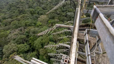
20 antennas were attached to the top of a 50-metre-high tower in the French Guianese forest to continuously measure the quality of the radar signal, which varies according weather conditions, time of day and other factors. © ESA/CNES/Arianspace/Optique vidéo du CSG – S. Martin, 2022 -
© ESA/CNES/Arianspace/Optique vidéo du CSG – S. Martin, 2022 -
© ESA/CNES/Arianspace/Optique vidéo du CSG – S. Martin, 2022
Forest inventory
“Biomass is a novel mission in that it’s using a radar, not to acquire imagery, but to extract biophysical data from the signal,” notes Thierry Koleck. Engineers and scientists therefore spent years on the challenge of devising what are known as inversion algorithms to convert the radar signal into useful biophysical data—a challenge further compounded by the radar signal being distorted by external factors like the ionosphere, humidity, wind or fallen trees, for example.
As a result, teams had to acquire a lot of field data. “Forests are complex and changing systems that are very hard to model,” explains Thierry Koleck.
Laurent Ferro-Famil adds: “The two values calculated by the satellite’s algorithms—biomass and forest height (see box)—are related via mathematical equations. But their parameters vary from one forest to another. The field data allowed us to factor these variations into our algorithms.”
One satellite, multiple data
Biomass is designed to obtain very specific data products—four, to be precise, serving an infinite range of applications:
- AGB (Above Ground Biomass): the biomass in tree trunks, branches and stems, calculated in tonnes of carbon per hectare.
- Forest height.
- Forest disturbances: as the satellite scans the same areas of interest several times, it’s able to track how forests change and to detect fires or deforestation, for example.
- A digital terrain model (DTM) of areas covered by dense vegetation, in other words, the topography of the underlying forest floor.
To optimize data quality and therefore the biomass maps the satellite will generate (with other satellites like the Indo-American NISAR), a global network has been set up called GEO-TREES, to which CNES is contributing. Its aim is to create a genuine forest inventory, a uniform global database, from different field studies. All data collected—tree height, trunk diameter, species, etc.—must follow the protocol defined by GEO-TREES, so that data can be cross-compared, wherever they come from.
Thierry Koleck is glad to say that “a strong scientific community has emerged around this mission, around the globe and in France. And supporting this community is one of CNES’s main roles.” For example, by funding PhD theses or projects accompanying the mission.
The Biomass satellite was designed to map forest biomass, but other applications soon came to light. “Each space mission brings its load of surprises,” says Thuy Le Toan with a smile. “And in this case we’re talking about the very first satellite equipped with a P-band radar.” So it will also be able to reveal what’s hiding under ice or sand, for example, like ancient riverbeds lying below the Sahara Desert. One thing is certain—Biomass is set to serve science.