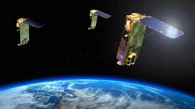
The objective of the CERES military mission is to gather signals intelligence from areas that surface sensors cannot reach, free from airspace overflight constraints and in all weathers, supporting conception and execution of military operations.
Key information
| Mission | Detection and location of electromagnetic signals from radiocommunication systems and radar |
|---|---|
| Domain | Defence |
| Launch date | 16 November 2021 |
| Partners | DGA, Airbus Defence & Space, Thales Defence and Mission Systems and Thales Alenia Space |
| Where | Low Earth orbit |
| Lifetime | Indefinite |
Key figures
- 3 satellites flying in formation
- 516 kg: mass of each satellite
Key milestones
- 16 November 2021 : Three satellites launched by Vega
- January 2015 : Start of execution phase
Project in brief
The space segment of CERES consists of three satellites flying in formation in low Earth orbit.
Signals collected by each satellite are combined to precisely locate communication systems on land and at sea.
The French defence procurement agency DGA is overseeing the CERES programme and is the main contracting authority for the system, satellites, user ground segment and through-life sustainment. It assures that the system delivered matches military requirements in terms of functionality and availability.
Space Command (CDE) surveys, synthesizes and expresses users’ operational needs on behalf of Armed Forces Chiefs of Staff. As the tasking authority for CERES, it ensures that the system is fit for operational use, signs off its adoption and defines policy regarding its use. A team of military technicians and engineers at CDE also works alongside CNES’s teams operating the CERES satellites at the Toulouse Space Centre.
CNES’s role
CNES is providing oversight assistance to DGA and has delegated responsibility for procuring launch services, for the ground control segment (SSC), satellite simulator and ground-to-space encryption systems. It is also in charge of orbital analyses, system tests involving the SSC and preparation and execution of satellite tracking. The agency is tasked with positioning the satellites and keeping them on station.
For any questions, please use the contact form.


