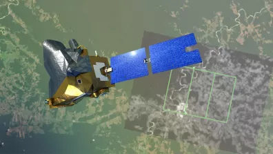
CO3D—for Constellation Optique 3D in French—is an Earth-observing mission built around four small optical satellites. Its unique feature is that these satellites will operate in pairs, simultaneously imaging the same area of interest from slightly different angles. The pictures obtained will then be merged to create a 3D image, just like our brain does from the images that our two eyes see.
“The goal of CO3D is to map all of Earth’s land surfaces in three dimensions,” explains Philippe Maisongrande, CNES’s Land Surfaces subject matter expert. “We’ll obtain not only maps showing terrain topography, but also surface features such as buildings, forests, crops, infrastructures and so on.”
Such data are valuable in many domains, notably for our planet. Delphine Leroux, CNES’s Water Cycle subject matter expert, is eagerly awaiting this mission. “We’ll be able to precisely map the elevation of river catchments and see the paths of rainwater flowing into rivers and how they evolve over time. This will help us better anticipate flood risks, for example.”
Tracking terrestrial water
Glaciologists are also showing a keen interest in CO3D, which has already been added to the Pleiades Glacier Observatory. For 10 years now, this programme has been tracking 140 glaciers around the globe, from Argentina to the Himalayas, employing satellite imagery—those generated by the Pleiades satellites and soon by CO3D. “With CO3D’s data, we’ll be able to track more regularly and with much more precision how glaciers are changing, melting and moving,” notes Delphine Leroux. “The volumes of water they store will also be more accurately estimated.”
The satellites will supply imagery acquired in different wavelengths, in the visible portion of the spectrum and also in the near-infrared, which lends itself well to clearly distinguishing vegetation. “CO3D will be a precious aid for surveying vegetation, crops and forests,” adds Philippe Maisongrande. “Using 3D data, we’ll be able for example to estimate tree height and therefore volume, useful for calculating their capacity to store the CO2 released into the atmosphere by planes and cars.”

The CO3D satellites are in fact like big photographic cameras with sensors offering a resolution of 50 centimetres. That means their images will identify features like isolated trees or hedgerows in farmlands, important in arresting the decline in biodiversity.
Serving local and regional authorities
CO3D is a mission designed, developed and funded by CNES (40%) and Airbus Defence & Space (60%), which will be the official commercial operator after an 18-month demonstration phase. This partnership ensures affordable access to the mission’s imagery for many national users like the Ministry for Armed Forces (see box), the scientific community, local and regional authorities and civil protection agencies. Moreover, every year CO3D will acquire imagery covering an area of 600,000 sq.km, which CNES will make available to French institutional partners free of charge.
A dual-use satellite
Data from the CO3D mission aim to meet both civil and military needs. This is what’s termed “dual use”. In the defence domain, CO3D data will help for example to plan low-altitude aerial missions and vehicle and troop deployments in all sorts of terrain.
Preventing floods, monitoring mines and precision agriculture are just some of the many potential applications. For local and regional authorities in particular, for whom a 3D picture of territories will improve land planning. A case in point is the green (land) and blue (aquatic) ecological corridors that animals rely on to feed and breed. Preserving these corridors thus helps to halt loss of biodiversity.
Urban planning will also be catered for. “CO3D imagery will notably help to generate very precise digital models of cities,” explains Philippe Maisongrande. “Such models detailing the nature of soils, a city’s spatial organization, what type of vegetation is planted and where will be supplemented with diverse data from a range of sources, for example on materials and street or building temperatures. I’m thinking in particular of data from the French-Indian Trishna satellite set to deliver precise surface temperatures from all over the globe.”
These models will enable climatology at the scale of a city or even a district, and help to combat urban heat islands where temperatures are highest. City councils will also be able to simulate wind dynamics to improve air quality, mitigate noise propagation or enhance buildings’ energy performance.
Where land meets sea
Over three years, CO3D is expected to generate a 3D map covering 125 million sq.km of Earth’s land surfaces—and beyond. For the mission will also survey all coastal waters up to the first few metres of land surfaces, which its instruments will be able to see. “Where the water isn’t too deep,” points out Lionel Perret, CO3D project leader at CNES.
And this is no mean challenge, as the retreat of shorelines—where the land meets the sea—is being exacerbated by climate change. According to CEREMA, the hazards, environment, mobility and land planning research centre, by 2028 some one thousand buildings in France could be affected, at a cost of €240 million (the value of the buildings). By 2050, more than 5,000 homes could be under threat.
“Numerous projects using CO3D data to address this issue are coming on stream,” confirms Jean-Baptiste Henry, in charge of the mission’s early adopters programme. “For civil applications but also for the military, who are interested in the precision of littoral data, for example to develop amphibious operations.”
Indeed, CO3D is a dual-use satellite designed to serve both civil and military requirements. “Data exploitation projects are already underway,” notes Jean-Baptiste Henry. “Like the project being pursued with SHOM, the French naval hydrographic and oceanographic office, that aims to develop a method to model coastlines continuously using CO3D’s ability to acquire bathymetry data down to 10-15 metres and topography data.”
For it is also CNES’s role to foster development of services and technologies relying on the mission’s data, and to ensure they find users and bring value, notably to help us adapt to climate change.
250,000 Lord of The Rings trilogies
CO3D will build up a 3D picture of 125 million sq.km of land surfaces, which represents 6,000 terabytes of data, the equivalent of 250,000 Lord of The Rings trilogies in high definition (the extended versions, of course!). To meet this challenge, CNES has developed special algorithms to process imagery and generate huge volumes of 3D imagery automatically in the cloud. And to optimize image acquisition, CO3D also features weather bulletins updated every quarter of an hour—that way, resources won’t be wasted by imaging when cloud cover is forecast.